FORECASTのTwitterイラスト検索結果。 1,645 件中 58ページ目


A big development with #Delta today is the continued motion south of yesterday's forecasts. With Delta still down near 16N, risk is decreasing for Grand Cayman, but markedly increasing for Cancun, Mexico, just days after being hit by Gamma. Delta likely to be much more dangerous.


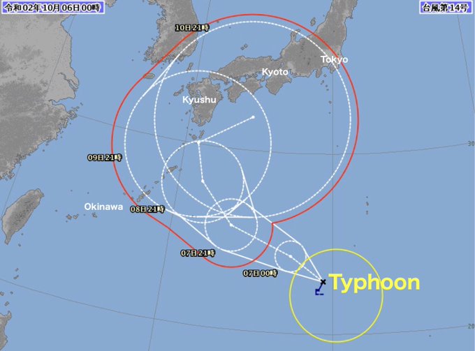
台風
03:30現在
photo:
①②Tropical Storm Track forecast map/US Navy
③ Typhoon forecast track/Japan Meteorological Agency 気象庁


台風情勢
12:29現在
photo
①② Tropical Storm Track forecast map US Navy
③ Japan Meteorological Agency Forecast track


#LOLtubre
Día 3: El último campeón que jugaste: Forecast Janna en ARAM, pero perdimos :c
#ArtofLegends #LeagueofLegendsArt #CreadoresDeLolLatam #Janna #Fanart


#mechamatober #day3 - Raining🌧
Yea weather forecast hasn’t been so accurate lately, eh Deep? Guess you forgot what people says, you gotta prepare an umbrella before the rain comes 😔
#mechamato #himechamato


#TD25 has formed, and will approach Mexico on Saturday. Strengthening is favored today. Max winds forecast to be ~45 mph near Mexico by NHC. In worst-case scenario, if inner core forms quickly today, could be closer to 60-80 mph. Regardless, flooding primary hazard for the region


Escalation in daily total intensity & monthly total estimated emissions of #Yakutia #wildfires over the weekend in #CopernicusAtmosphere GFAS monitoring & continuing high surface PM2.5 #AirPollution in 28/09 forecast visualized by @windyforecast https://t.co/HXh8jqEinf https://t.co/WxLo816qdI


Good morning! Today's “Onsen Nyanko” is “Nyanko to eat dumplings”!
Sunday. The rain in the Kanto region is forecast to end today. I wish you the lucky ☆ of Nyanko today! Please enjoy it.


If the skies remain clear as forecast, we're off to darkest Perthshire for a spell of stargazing tonight.
Just so many more choices at this time of year. But which one?
The Forbidden Planet?
Flying saucers?
Metaluna?
LV-426?


🔥Recent aerosol optical depth forecasts from our Atmosphere Monitoring Service show that smoke from the #CaliforniaFires and #OregonFires continues to make its way to #Europe, after it had reached #Finland yesterday.
Find more @CopernicusECMWF forecasts: https://t.co/lgsrctlmif


台風 (日本気象庁呼称) 直近情報
17:40現在
photo:
① US Navy Satellite
②Tropical Storm track forecast map / US Navy
(※米軍呼称・表示=熱帯低気圧)


man dont you just hate it when youre minding your own business and then out of nowhere it starts POURING DOWN RAIN and you didnt expect it to rain today cause it wasnt forecasted on the weather so you didnt bring your umbrella so now you have to run t- oh no


By Max Cole
https://t.co/spRi3hJiXH
There is rain in the forecast – most welcome rain!
“Brushing the clouds away from my eyes, I see clarity in the raindrop and beauty in the first ray of morning sun...
Life is strange and wondrous...”
― Virginia Alison


@BBigfloppa The impossible: my garbage sparkle dog (his name is Hurricane, though Forecast and Chance of Rain was tempting)?