NHCのTwitterイラスト検索結果。 48 件中 2ページ目


【Tokyo 7th シスターズ】Pレアカード アユム おモチの気持ち GETしたよ!皆も遊んでね♪→https://t.co/sauwLcJNjg 【プレイヤーID】Nhc4QVA #t7s #ナナシス

【Tokyo 7th シスターズ】Pレアカード ミワコ ボルダリング GETしたよ!皆も遊んでね♪→https://t.co/sauwLcJNjg 【プレイヤーID】Nhc4QVA #t7s #ナナシス
乳!!!!!!!!!!!!!!!!!!

【Tokyo 7th シスターズ】Pレアカード ホノカ ミツバチジャケ GETしたよ!皆も遊んでね♪→https://t.co/sauwLcJNjg 【プレイヤーID】Nhc4QVA #t7s #ナナシス
CASQUETTE'Sの新メンバーか?

【Tokyo 7th シスターズ】Gレアカード サワラ イチゴ狩り GETしたよ!皆も遊んでね♪→https://t.co/sauwLcJNjg 【プレイヤーID】Nhc4QVA #t7s #ナナシス

【Tokyo 7th シスターズ】Pレアカード ハル カバーウィッチ GETしたよ!皆も遊んでね♪→https://t.co/sauwLcJNjg 【プレイヤーID】Nhc4QVA #t7s #ナナシス

【Tokyo 7th シスターズ】Gレアカード シズカ 頬が落ちそうなご馳走 GETしたよ!皆も遊んでね♪→https://t.co/sauwLcJNjg 【プレイヤーID】Nhc4QVA #t7s #ナナシス
なんちゅう服着とんのや。

【Tokyo 7th シスターズ】Pレアカード スース これを入れれば…! GETしたよ!皆も遊んでね♪→https://t.co/sauwLcJNjg 【プレイヤーID】Nhc4QVA #t7s #ナナシス

【Tokyo 7th シスターズ】Gレアカード ウメ 聖夜のパーティー GETしたよ!皆も遊んでね♪→https://t.co/sauwLcJNjg 【プレイヤーID】Nhc4QVA #t7s #ナナシス
やったー!!!!!!!!!!!!!!!!!!!!!!!!!!!!!!!

【Tokyo 7th シスターズ】G+レアカード エモコ スーパーレシーブ GETしたよ!皆も遊んでね♪→https://t.co/sauwLcJNjg 【プレイヤーID】Nhc4QVA #t7s #ナナシス

【Tokyo 7th シスターズ】G+レアカード シンジュ 楽しい夢の中 GETしたよ!皆も遊んでね♪→https://t.co/sauwLcJNjg 【プレイヤーID】Nhc4QVA #t7s #ナナシス

【Tokyo 7th シスターズ】Gレアカード ジェダ ヨガストレッチ GETしたよ!皆も遊んでね♪→https://t.co/sauwLcJNjg 【プレイヤーID】Nhc4QVA #t7s #ナナシス

【Tokyo 7th シスターズ】Gレアカード 逢原ミウ ラクロス練習中 GETしたよ!皆も遊んでね♪→https://t.co/sauwLcJNjg 【プレイヤーID】Nhc4QVA #t7s #ナナシス

【Tokyo 7th シスターズ】Pレアカード KARAKURI スタードレス GETしたよ!皆も遊んでね♪→https://t.co/sauwLcJNjg 【プレイヤーID】Nhc4QVA #t7s #ナナシス

【Tokyo 7th シスターズ】Pレアカード KARAKURI 遠くまで GETしたよ!皆も遊んでね♪→https://t.co/sauwLcJNjg 【プレイヤーID】Nhc4QVA #t7s #ナナシス ウワーーーーッ

【Tokyo 7th シスターズ】BDレアカード ターシャ BIRTHDAY GETしたよ!皆も遊んでね♪→https://t.co/sauwLcscrI 【プレイヤーID】Nhc4QVA #t7s #ナナシス オワーーーーーーーーーッ

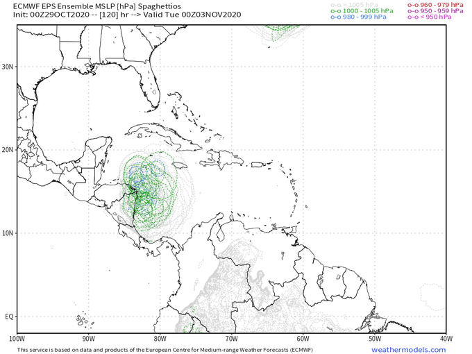
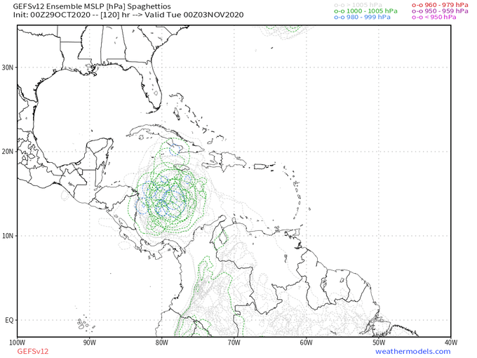

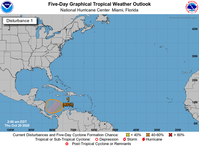
Robust signal for new tropical cyclone development in the Caribbean continues on overnight ensemble guidance (both GEFS and EPS) as a wave and cold front enter the basin under strong upper-level divergence.
NHC development odds now up to 40%.
Model maps: https://t.co/m0Yjxszm1d


Latest HWRF just out for Hurricane Zeta:
Showing 85kt at landfall near New Orleans, right in line with the latest NHC forecast. Still expect it will be a Cat 2 at landfall, but it's good to prepare for a borderline Cat 3 given #2020


@iCyclone This was what I got. 10:30UTC (5:30am CDT) landfall (used landfall time from NHC). Hopefully the image is to your liking.


#TD25 has formed, and will approach Mexico on Saturday. Strengthening is favored today. Max winds forecast to be ~45 mph near Mexico by NHC. In worst-case scenario, if inner core forms quickly today, could be closer to 60-80 mph. Regardless, flooding primary hazard for the region


TS #Amanda formed last night and has since moved ashore in Guatemala, bringing heavy rainfall/flooding with it. After it dissipates later today, the remnant energy should track NW about the CAG center into the Bay of Campeche, where the NHC now puts a 50% chance of TCG in 5 days.