Those wanting rain in the week ahead will be disappointed. High pressure means dry weather. A front will bring cloud on Tuesday but little rain. In #Wales this spring is likely to be in the top 10 driest since records began in 1862 with less than 150mm! Average rainfall 292mm.
April has got off to a chilly start but warmer air will arrive over the weekend with south to southeast winds. Sunday the warmest day and breezy. Plenty of dry weather. Some spring sunshine but rain will spread from the west during Sunday evening and night. @BBCWalesToday 2230
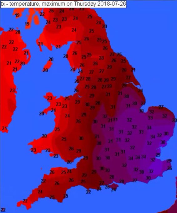
Top temperatures in #Wales today 20 to 26 Celsius
Hotter tomorrow! 35 Celsius in #London and SE England
But if you don't like the heat and humidity, a cold front is on the way!
Windier on Sunday with some significant rain possible.
Latest forecast @bbcwalestoday 1830
July outlook: much drier and warmer than average with high pressure dominating. Increased risk of heatwave conditions and drought.
Some showers or thunderstorms possible at times.
There is a chance of more mixed weather after mid month but no sign yet of a major breakdown!
Satellite shows #Wales basking in sunshibe with a few wispy cirrus clouds.
Warmer than yesterday with light sea breezes
Sea temperature typically 13 or 14°C
Snow depths by 6am tomorrow from the Arpege @meteofrance @wxcharts Big variation across #Wales. Most of the snow in the east and southeast, especially high ground. Much less in parts of the west & #Swansea because of the wind direction. E-NE with shelter from the hills/mountains.


