
Eric Holthausさんのイラストまとめ
@EricHolthausFollow @EricHolthausさんをフォローする
🌹 You were born at just the right moment to help change everything. 🌹
@ericholthaus.com on Bluesky
フォロー数:19819 フォロワー数:431786


The 00z HWRF has #Fiona as a Category 3 major hurricane directly over Sable Island, Nova Scotia on Saturday morning. https://t.co/wPEvfjvF9A

Latest HWRF just out for Hurricane Zeta:
Showing 85kt at landfall near New Orleans, right in line with the latest NHC forecast. Still expect it will be a Cat 2 at landfall, but it's good to prepare for a borderline Cat 3 given #2020

In exactly three days from now, here's what the HWRF model says a Hurricane Laura could look like as it's approaching the Gulf Coast.
I'll say it very simply: Laura poses a potentially catastrophic threat to the Texas and Louisiana coast.
Watch this storm very closely.
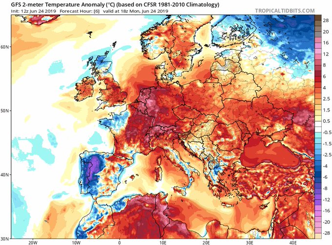
This week, a multi-day heat wave will challenge all-time high temperature records for any month of the year. Temperatures in Spain, France, and Italy could reach as high as 40-42°C (104-108°F) -- about 10-15°C (18-27°F) above normal, remarkable for June.
https://t.co/3q3HOnbZ3i


OK you guys, my intention is not to scare anyone with this message.
But Hurricane #Florence—the storm bound for North Carolina—is going to be about the size of North Carolina when it arrives.
This is what it will look like, according to the latest high-res model prediction:

A truly horrific image:
Hurricane Irma is the size of Florida in tonight's high-res HWRF model prediction of Sunday morning. Heaven help us.

If you live in S Florida, this is all you need to take #Irma very seriously.
Remarkable agreement between GFS & Euro, our two best models.

Latest (12Z) GFS shows extremely heavy rainfall from Hurricane #Harvey encroaching further inland. Austin & San Antonio should be alert.

Huge burst of unseasonable warmth heading from Russian Arctic toward North Pole this week. In some places, 60 degrees F warmer than "normal"