Daniel Coeさんのイラストまとめ
@geo_coeFollow @geo_coeさんをフォローする
フォロー数:222 フォロワー数:6171


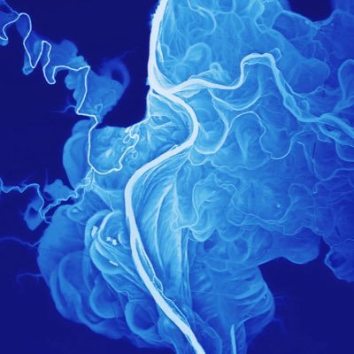
The braided channels of the #KnikRiver flowing from the Knik Glacier in the Chugach Mountains of Alaska. Expand for full view. #lidar data from @akdggs


#WabashRiver #lidar with original orientation-expand for full view. Download the image here: https://t.co/EW3J5tnfKJ

Experimenting with #REMA data from @polargeospatial tonight. Here is an image of #glaciers flowing onto the #RossIceShelf, #Antarctica
data: https://t.co/lCL7FgOnQl
image: https://t.co/WMjSaCpJhp


#Lidar-derived images of the #ColoradoRiver #Delta in #Mexico, a place that has gone through extreme environmental change in the past century. #intertidal #gulfofcalifornia
data: https://t.co/P9GqVPSmHU
images:https://t.co/TWEgDnpYXA

The #IvaloRiver in #Lapland, now with a little #shadedrelief added in for context. Fun to compare the present-day river to past channel locations. Also—bonus dune features at the top of the image. #Finland #dunes #sinuous
#lidar data: https://t.co/CsbEaD7DiG

#Lidar viz from a mesmerizing 5 km. wide section of the #YukonRiver #floodplain near Fort Yukon, AK. 5 meter elevation range displayed. None of these channels are active. Data from Alaska DGGS elevation portal: https://t.co/QERvpncoQ6 #geomorphology
