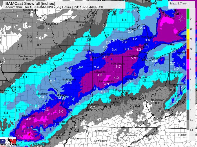
A couple of the mid-day data runs for Wednesday's GFS remains aggressive but north. Our custom BAMCast may be a reasonable track, though we've like the Euro's consistency so far. It runs in about an hour.


Track the Storm: https://t.co/muJ1ZEzPYD

7 50

Video still of the Maroa, IL Tornado on 1-3-23. Caught this coming from SW of town crossing Bearsdale Rd around 4:30pm, soon crossing Rt.51 where a farm would be damaged. Rated EF-1 with estimated winds 110mph.

46 279

Alright then, an Iowa snowcane.

KDMX - Precipitation Depiction 7:02 AM

21 122

Data continues to show some areas of 8"+ of snow across north-central IL into northern IN.

9 24

Here is the forecast snowfall through Thu morning. 12"+ of snow are possible into portions of IL/IN. Keep in mind, there will likely be some changes to track & amounts in the coming days so stay tuned!!

9 27

Snowfall outlook for the next 15 days...crickets. (Except across northern Wisconsin and Michigan). We'll continue to see above normal warmth favored through the end of the month.

5 16

Ok, so maybe afternoon models weren't all that crazy? New high-resolution data (HRRR and NAM3) just came in with monster totals across central Indiana into west-central Ohio through Tuesday morning as well.

18 48

Round 2 of the storms that came through S Lake Michigan today produced lightning, rain and gusty winds.

2 5