Ready for another round of record-breaking heat?

by Global Forecast System (#GFS)- a numerical modeling framework that uses a 13 km Finite-Volume Cubed-Sphere dynamical core (#FV3)

0 3

The temperature forecast for today calls for highs in the 70s and 80s across most of Texas with colder highs in the 30s and 40s across portions of the Texas Panhandle this afternoon. Two seasons across Texas today. Image via HRRR/NCEP/NOAA

1 3

2022年6月12日

GFS / NCEP / US National Weather Serviceの風向予報と DTN° が一致しました。

東電福島原発からの風は14日(火)までに大阪府まで到達する予報。

21 26

2022年04月14日

東電福島原発からの風はかなり内陸まで吹いています(GFS / NCEP / US National Weather Service)とアメダス。
近畿方面も風下になる予報。

DTN° meteocentrale 放射能拡散予報は停止中。

10 18

風向予報がころころ変わってます。
GFS / NCEP / US National Weather Service

動画は2022年
3月24日24時から
3月25日24時まで。

1時間置きの表示更新で 48回。

12 20

2022年1月21日

1月24日の午後から、東電福島原発からの風は関東に吹く予報になりました。

GFS / NCEP / US National Weather Service

20 32

Is it a bird? Is it a plane? It’s as visualised by https://t.co/Qr3jav3LkB from GFS/NCEP/US National Weather Service data. Tomorrow will be “interesting”. Please take care.

1 22

2021年10月31日

GFS / NCEP / US National Weather Serviceの予報。

東電福島原発からの風は、
明日11月1日の未明(5時頃)から関東に吹きます。

画面の表示更新は8時間毎。

29 29

9月15日には、四国沖に低気圧(台風?)が発生する予報(GFS / NCEP / US National Weather Service)になってます。
これより前の13日頃から、東電福島原発の風は西日本の太平洋岸へ。

27 36

2021年8月31日

あと数時間で東電福島原発からの風が千葉方面に吹き始めます。

風は 31日のお昼前には関東の内陸深くに。

添付の予報は
GFS / NCEP / US National Weather Service

23 33

【#ラニーニャ】最新の (アメリカ海洋大気庁)のエルニーニョ監視週報では、NOAAのNCEPの予報モデルがはっきりと今冬のラニーニャ傾向の予想をし始めている。現時点でラニーニャ傾向を予測しているにはNCEP、NASA、COLAの3つで、いずれもアメリカの予報機関。果たして久々の になるのか注目

40 78

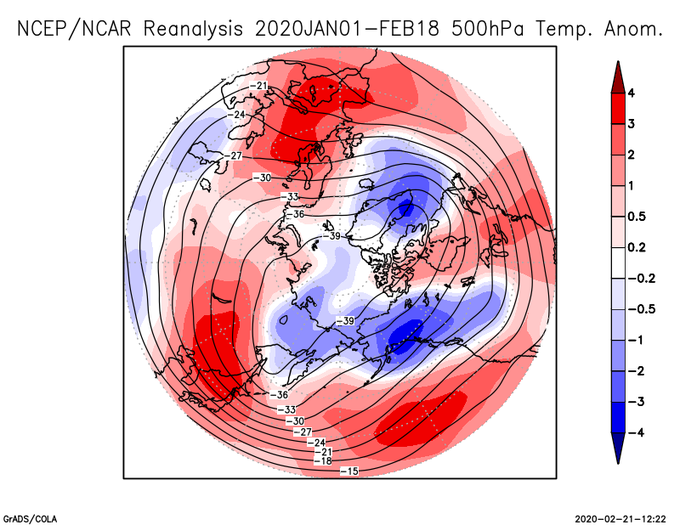
ncep/ncar再解析による, 2020年1月1日~2月18日の500hPa気温平年差(1981-2010平均との差)。日本域では平年より2-3℃高かった。

3 5

久しぶりにNCEP/NCAR掘り起こして書いたけど, 1月第1半旬の850気温はこんなんなった この期間は西半球も暖かそう

0 1

Autumn 2019 500mb height anomalies and 250mb zonal wind speed anomalies, via & Perhaps no surprise to see the most negative 500mb height anomaly for the autumn, over the whole N Hemisphere mid-high latitudes was sat over the UK! Southerly displaced jet stream 🌧️☔️💧

2 1