Lightning risk for the BC Interior this week...⚡️🔥
An upper low puttering around off Van Isle will support favourable conditions for thunderstorms (perhaps severe on Thursday) in the interior from Wed-Fri.
It could then cause problems across the prairies through the weekend.
Portrait of a monster.
This storm dropped grapefruit-sized hail that blew out the windows of many terrified motorists stuck on the side of Alberta's busiest freeway on Monday evening. #abstorm
Sandwiched between low and height mid-level height anomalies lies a strong jet stream over the Alberta Rockies - a recurring pattern through month-end.
Given recent rainfall, moisture availability will be plentiful.
Could be seeing an active stretch of severe weather...
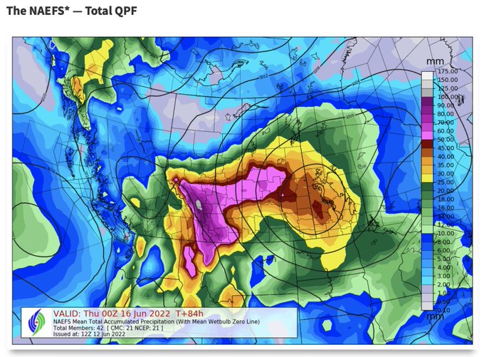
Heavy rain will bring flood risk along the foothills, but how does it compare to 2013 in Calgary?
Buffers:
- Low water table, slow mountain melt = below normal flows into reservoirs ahead of event
- Lower freezing levels, alpine snow
- >50% better flood resiliency in #yyc
Looks like we're in for some significant rain across much of the western prairies over the next few days!
In Calgary, now is a good time to ensure those gutters and storm drains are clear of debris, with downspouts pointed away from yours and your neighbours foundations #yyc
Always honoured when artists paint my images. 😍
Look at this beautiful piece by Jerry Berthelette, Alberta Metis artist!
More of his work is at Great Bear Originals on FB and Insta 👊
Could see some truck-tipping winds on Monday afternoon and early evening south of Calgary, especially on Hwy 2 between Nanton and Fort Macleod.
Gusts in excess of 110km/h possible. Travel with caution. #abstorm


