🗺️Interested in understanding the makeup of your city & its surroundings?
🏠Using @CopernicusLand's Urban Atlas, you can find out land use & cover. For example #Prague, 🇨🇿 shows high levels of urban and industrial land use, with some large green areas.
🔗https://t.co/YKGDMSnbdx
🔥Recent aerosol optical depth forecasts from our Atmosphere Monitoring Service show that smoke from the #CaliforniaFires and #OregonFires continues to make its way to #Europe, after it had reached #Finland yesterday.
Find more @CopernicusECMWF forecasts: https://t.co/lgsrctlmif
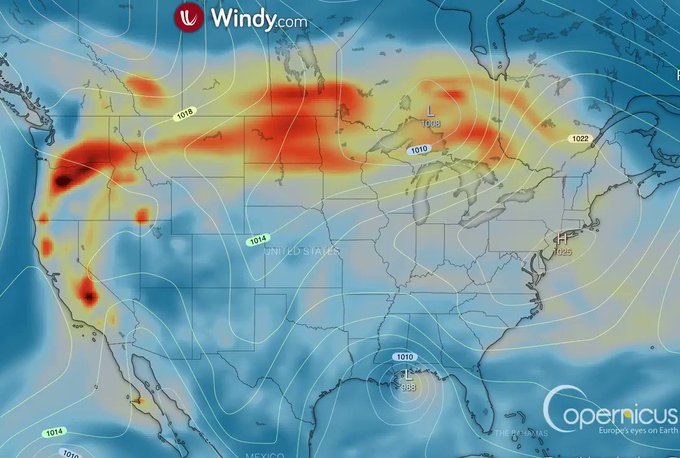
🔥Smoke deriving from the #CaliforniaFires and #OregonFires is being carried across the US.
This animation shows aerosols spreading from the West Coast all over the country & Canada.
@windyforecast uses forecast models from our Atmosphere Monitoring Service @CopernicusECMWF.
🔥The number of fires in the Brazilian Pantanal last month was the second-highest on record for August, according to #Brazil's @inpe_mct.
On 29/08, #Sentinel2 (custom script by @Pierre_Markuse) shows us several fires close to the Pantanal, the world's largest tropical wetland.
This week's #SentinelVision comes from Sentinel's 1 and 3 - showing Hurricane Laura, the most powerful hurricane to hit the state of Louisiana, USA.
👁️https://t.co/je1AafvQnF
🦒 The #Etosha pan salt desert and national park in Namibia has very rich biodiversity. The data generated via our #climatechange service (#C3S) can be used to help protect it.
📷 Check out the view captured by #Sentinel2🛰️:
https://t.co/b7oarqMbYl @CopernicusECMWF #EUSpace
🌍Happy #EarthDay!🥳
The #Copernicus programme🛰️🇪🇺 makes it possible to keep track of our planet's health.
Its full, free, and open data is essential to monitor and to mitigate the damaging effects of #ClimateChange.
#EUSpace
Many times our 🌍 show us extraordinary natural phenomena!
A good example is the Richat Structure aka the Eye of #Africa, a circular geological feature in Mauritania 🇲🇷.
It has a diameter of approximately 40 kilometers & can be easily spotted from #Sentinel2 🛰️🇪🇺!
.@CopernicusCMS supports a better understanding & improved monitoring of activities at sea.
For instance, it offers wind and wave information services, such as speed, height & direction.🌊
➡️Discover more on the products: https://t.co/TTWGenuIJJ
Copernicus services play a crucial role in monitoring the environmental changes taking place in the #Arctic.
Data from @CMEMS_EU @CopernicusECMWF& @CopernicusLand support the #EU's Arctic policy: https://t.co/2zLvhalwjO.
📸 #Sentinel2🛰️🇪🇺 capture of Svalbard in #Norway 🇳🇴


