Sentinel2のTwitterイラスト検索結果。 35 件


Sentinel2の同パス撮影をさかのぼる形でgif動画とし、火口輝点の位置と生成された池の位置を比較しました。
投稿動画フレームの撮影日とRGB処理は
2/28、2/23、2/18:RGB 8,4,3
1/14、1/9:RGB 12,11,4
2月に生成した火口池(猫池)の位置は、1月初旬の火口位置の若干南東側にあるようですね。


Random Series | Wonders of Crooked island & Long Cay defining the northern part of Bight of Acklins shallow lagoon. White beaches & crystalline waters in the Bahamian islands (Acklins not visible) 🏝️ (v.2)
#Copernicus #Sentinel2 🛰️ #EO
Full Size: https://t.co/NTbVzs84Mg 🧐

It is not only #US mid-west, S. #America, E. #Africa or #Europe, look at Poyang Lake in Jiangxi province #China (Image: 90x90 km‼️), "it has shrunk to a quarter of its normal size for this time of year"
Evolution in only 1⃣ month 15/07 to 14/08⬇️ @CopernicusEU #Sentinel2 🛰️ 2022

Meanwhile in Kamchatka | Shiveluch 🌋 v2
With its accompanying IR signature, smoke column & clouds, this #volcano continues offering an amazing spectacle every year & conforms one of my favorite images
#Copernicus #Sentinel2 🛰️ 2022-07-18
Full Size -> https://t.co/M7CwqDjO7x 🧐

@CopernicusEU Here you go the extra static version of the previous video (open thread):
The beauty of Athabasca Lake & Sand Dunes while ice retreats | #Copernicus #Sentinel2 🛰️ 2022-05-31 #EarthArt #Canada
Full Size -> https://t.co/nlTiDyX5GY 🧐 #EO


@kosmi64833127 @CopernicusEU @sentinel_hub ….and a little bit closer…. ;-) with IR-Signals
Seen from 🛰#Sentinel2
#AnakKrakatau #Krakatoa #AnakKrakatoa
Footage: @CopernicusEU @sentinel_hub

Random Series | Shark Bay 🦈 27x15 km
With one of the largest & most diverse seagrass beds in the world, this World Heritage Site is in the Gascoyne region of Western #Australia. @UNESCO Id: 578
@CoperniusEU #Sentinel2 🛰️ 2022-02-23
Full Size -> https://t.co/UjUqwPIHUs 🧐 #EO


#Satellite #photography of
#NorthSea Isle of #Spiekeroog
False color urban layer 2022 - Red urban areas
#Sentinel2 #Copernicus #remotesensing
@sentinel_hub
@CopernicusEU
@CopernicusLand
#QGIS #OpenData #EarthArt #EarthObservation #DataScience #dataviz #OpenScience
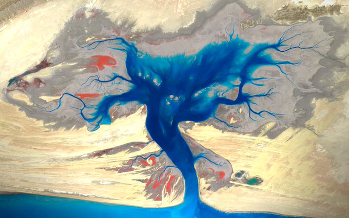
#TreeOfLife 🌳| Buzi Makola Wildlife Sanctuary
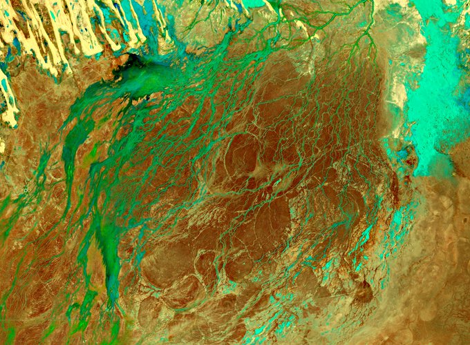
False color, low tide image of this managed #NatureReserve located in Sindh, near Makran Coastal Highway #Pakistan - #lUCN management Category IV
@CopernicusEU #Sentinel2 🛰️ 2022-04-01
Full Size -> https://t.co/hPbHyxa2WK 🧐 #EO


Australia's inland deserts alive with water after weeks of torrential rainfall and flooding.
3 Feb 2022 @CopernicusEU #Sentinel2 false colour imagery; water appears as bright blue, vegetation as bright green.
#DigitalEarthAU https://t.co/FbqHcZ0O2W

#Copernicus for #WorldWetlandsDay
Rising temperatures are threatening fragile #wetlands in the #Arctic environment
In the wetlands of the Lena Delta 🇷🇺, Nitrous oxide (N2O) emissions caused by melting permafrost have been observed
⬇️#Sentinel2🇪🇺🛰️ image, acquired in May 2021


StoriesOfSaharaDesert🏜️ Dunes in #Morocco 🇩🇿🌍 #EarthArt🎨🖌️🖼️#GEE #Sentinel2 🛰️ #AfricafromSpace #FalseColour #Geology
@CopernicusEU @BritGeoSurvey @RAM_Maroc


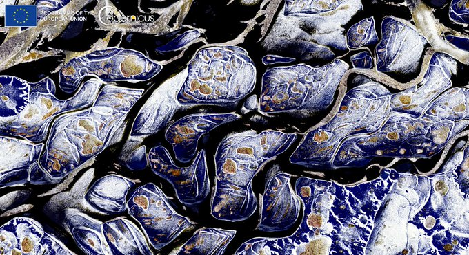
Ice in the Wadden Sea
⬇️#Copernicus #Sentinel2 image acquired today (26 December) of Vlieland island 🇳🇱

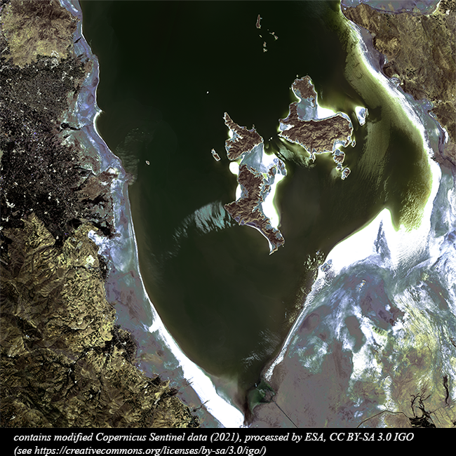
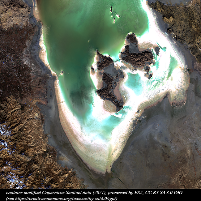
In past years the #Urmieh Salt Lake, a #BiosphereReserve in NW #Iran, has faced a dangerous #drought. Nowadays, it seems to be recovering as depicted in this comparison between a spring (more water) and an autumn acquisition. #Copernicus #Sentinel2 2021 images, visible channels.
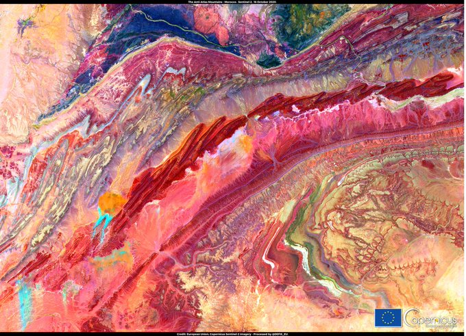
#Copernicus for geological mapping
Satellite-based information helps to catalogue geology and mineral resources
#Sentinel2 🇪🇺🛰️ false-colour image, combining several bands of the multispectral imager to highlight the different rock types in the Anti-Atlas Mountains #Morocco 🇲🇦


📷 This @CopernicusEU #Sentinel2 image taken on 10 October shows a new flow of lava from the #volcano erupting on the Spanish island of #LaPalma 👉
https://t.co/xe2rMwNLN4

The low lying coastal geography of the region makes the Mekong River Delta vulnerable to climate change & sea-level rise, and to related issues such as coastal erosion & saltwater intrusion
It can be monitored with our #OpenData
#Sentinel2 🇪🇺🛰️ image processed by @i_ameztoy
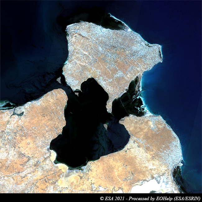

These #Sentinel2 images, acquired in 2021 and processed in visible channel, takes us over #Djerba. It is the largest island in North Africa (514 km²), located in the south-eastern part of the Gulf of Gabès, at the mouth of the Gulf of Boughrara, in the south-east of #Tunisia.


#Sentinel2 2021-04-04 #Australia
Salt lake Mackay between
Northern and Western Territories of Australia
Image bands SWIR
@CopernicusEU