
NatGeoMapsさんのイラストまとめ
@NatGeoMapsFollow @NatGeoMapsさんをフォローする
フォロー数:216 フォロワー数:36251


A giant sequoia named "The President" is the third-largest tree on Earth by volume. Read the story in the December 2012 @NatGeoMag https://t.co/jzgLtz6YLI
#sequoia #sequoiakingscanyon #tree #ancienttrees

Map of the Day: From St. Louis to the Pacific Ocean and back—some 8,000 miles of travel in 28 months—Meriwether Lewis and William Clark crossed the territory of the newly acquired Louisiana Purchase. This December 1988 map reveals the flora and fauna found on their journey.

‘Off-the-charts’ heat to affect millions in U.S. in coming decades https://t.co/o9kAbCdh6K
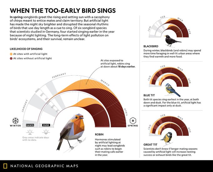
Some birds are singing earlier, and we may be the reason https://t.co/pwY9SDamqJ

Lost at sea: why the birds you don’t see are fading away https://t.co/q0CM0TxyZO
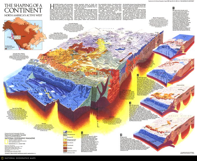
Map of the Day: This graphic depicts the shaping of the North American continent. Published in August 1985, the geologic profiles of the west span the past 90 million years, showing the region north of a line connecting northern California and central Colorado. #MapOTD


Venetians are used to getting their feet wet; efforts to alleviate the long-term effects of water are part of daily life in the city. This August 2009 map shows how during the acqua alta, unusually high tides cause floods. The lowest lying areas are most often inundated. #MapOTD

Some birds are singing earlier, and we may be the reason. https://t.co/DVM7GUahzf

How China plans to feed 1.4 billion growing appetites https://t.co/VmJb53aqwM