
The Map Houseさんのイラストまとめ
@TheMapHouseFollow @TheMapHouseさんをフォローする
フォロー数:826 フォロワー数:1887


#InternationalWomensDay
Celebrating #women in #maps with this powerful and beautiful atlas frontispiece (Wise, c1840). 🌍🌏🌎
Head to https://t.co/uSnvUGxo39 where will be shining a spotlight on female map makers and publishers in The Map House collection. #womeninmaps


‘When Maps Go to War: Pictorial Conflict Maps, 1900-1950’, a free talk by Director of The Map House and co-author of 'War Map', Philip Curtis 🌍
Tomorrow, Thursday 20th February, starting 5pm at the Warburg Institute (@Warburg_News, @UCL)🏛
Info: https://t.co/q1Y8MeJMHw #maps


#OTD 1909 explorers Ernest Shackleton, Frank Wild, Jameson Adams & Eric Marshall created a 'Farthest South' record in Antarctica - 88°23'S. Just 97miles from the pole🇦🇶📍[https://t.co/MzhheeEjRN]
Find out more in our C❄❄L book "The Mapping of Antarctica" https://t.co/aC9Cejcd50


Announcing our collaborative exhibition at 5 Carlos Place with @MATCHESFASHION.
Adorning the walls, a carefully curated and evolving collection of exquisite original antique and vintage #maps & prints.
Runs until Fri 28 Feb 2020.
https://t.co/yf1edF9fpv
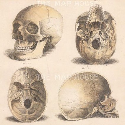


🎃🌍 Beware! It's not just #mapmonsters lurking in the galleries of The Map House.. 💀🧠 This #Halloween, we've dusted off some gruesome #antique anatomical prints especially for you👁🕸 [Lizars, c.1822-40]
See the collection, if you dare: https://t.co/u98v0VvIbO


"One equal temper of heroic hearts. Made weak by time and fate but strong in will. To strive, to seek, to find and not to yield" #OTD 1912, British #Antarctic explorer, #CaptainScott died. Discover Scott's photographs of the Terra Nova Expedition, 1910-12: https://t.co/t5YnCbXCOg


Spring has sprung 🌿💐 Beautiful #antique copper engravings by British author and #botantist, Dr. John Hill, which were published in his illustrated compendium "The British Herbal" (1756)🌼🌹
Visit https://t.co/u98v0VvIbO or pop upstairs at The Map House and peruse the collection

Stunningly detailed #map of the approach to #MountEverest from southern Nepal 🗺 Published 1957 and based on a pioneering photogrammetric survey by gifted Austrian surveryor Erwin Schneider, part of the 1955 Intl. Himalayan Expedition 🏔 #TravelTuesday https://t.co/BRcjW1SQoI
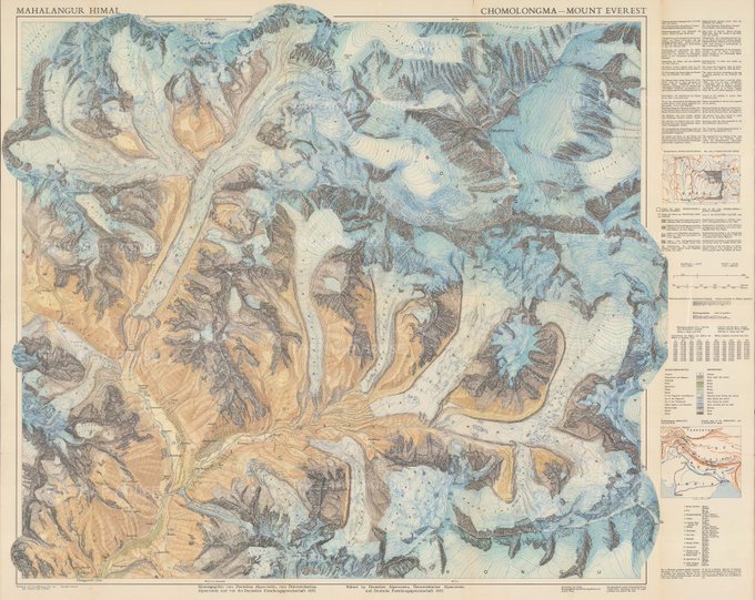


March #maps acquisitions include... 🌍 section of South East #London from Rocque's landmark survey (1674) 🌎 #Barcelona (1858) 🌍intricately detailed map of #MountEverest (1957) 🌏 Victorian tourist map of the Battle of #Waterloo (1845). See more: https://t.co/5wb36FW8R7

Pinch punch first edition on the first of the month🗓🌬This chilly day, we bring you Stanford's 1904 map of Antarctica - the first map of the South Pole to feature in Stanford's "London Atlas" and marks Shackleton & Scott's furthest south (1902). See more: https://t.co/2CAMnFXnOv