SaiasのTwitterイラスト検索結果。 222 件中 6ページ目


heres the full piece of the saias i drew for @EmblemGinger 🥺🥺💖
there are still some extra copies left so check them out if youre interested!! https://t.co/qTsK0qbk4e
#fireemblem

i like when artists draw saias with his cape looped around on his left side + pinned in the front like in his meet the hero but i prefer the idea that he has to carry his cape around all the time so it doesnt drag on the ground. like a cavalier king holding its ears in its mouth


#HurricaneIsaias knocked out my power so let's have a...
🖕🌀 ART SHARE 🎨
💨 Post your work, links, and a fun fact about yourself or your art!
💨 Comment on at least 1 other post!
💨 Retweet this for more exposure!
#artshare #artistsupportpledge #ArtistOnTwitter #DigitalArt


Storm surge going up the rivers and creeks is going to be the biggest issue here on the NE side of the storm over the next 2-3 hours as #HurricaneIsaias continues on its current track. #wxops #Windy #weather


Left: Tropical Storm #Isaias at 6:51 pm EST today, seen by @NOAA's GOES-16 satellite.
Right: Storms on Jupiter seen by @NASAJuno and processed by Gerald Eichstädt and Seán Doran (@_TheSeaning)
Note that the ENTIRE scene on the left fits inside the white box on the right.


Early stream tonight due to Isaias saying hello to me tonight! Working on Chibi Kiryu from #Yakuza! Come and join the fun!!
https://t.co/g1KQZUgKke
#yakuza0 #yakuzakiryu #yakuzagame


Its a Monday, a Monday that requires us to batten down the hatches, bring in the deck furniture to the porch, secure the pool floats, move my pots of herbs and cover the grill, but its #MajesticMonday too, so there's that ! #Thorin #HurricaneIsaias. #Hugs

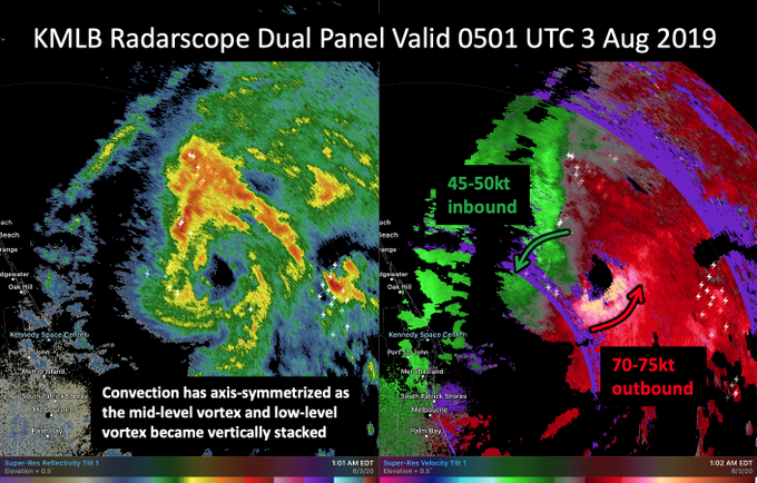
Concerning trends with #Isaias tonight.
The earlier radar hole now appears to becoming a bonafide eyewall with significant inbound & outbound velocities on KMLB radar. The low & mid-level center now appear aligned as convection axis-symmeterizes.


Tropical Storm #Isaias slowly reorganizing itself, with very intense convection. If it can align the vortex, strengthening will resume.


Been so busy at work last 8 hrs I haven't been able to check on #hurricaneIsaias .
That is looking pretty damn organized again and that eye is apparently a pin point eye. Very small. Still more Northeast dominate but back up to 80mph. :O

Hurricane #Isaias is improving a lot this evening. Outflow to it's W is expanding while very intense convection is flaring in the eyewall. Likely beginning a round of intensification.

A new microwave pass juuusst managed to snag the center of #Isaias, and shows that the eyewall has now closed itself off.
Recon confirms this, and satellite imagery shows large and very deep convective bursts flaring in the eyewall, a harbinger for intensification.


Hurricane Isaisas (ees-ah-EE-ahs), uncertainty, could possibly hit East inland Florida, yet predicting pushing West slightly in Ocean.
Reside on E. Coast, will be impacted somehow. Prepared. Will keep all posted.
#hurricaneIsaias

As microwave imagery reveals a forming eyewall, strong hot towers are firing once again, this time upshear of the storm. A sign of further organization. #isaias

#Hurricane #isaias has a terrifying smile, defined by intense convection.

The HMON model is the only one of the 00z package with the latest recon info, and intensifies #Isaias to a major hurricane after it's passage through the Bahamas.

Update: #Isaias is now a Hurricane, the second of the 2020 Atlantic Hurricane season.

Will take a bit tonight for #Isaias to get going again fully but the structure is clearly there for it to go. It's trying to get that classic comma shape to full wrap up but just as a little bit of dry air it's fighting right now on the West side. The core is very much alive.