ecmwfのTwitterイラスト検索結果。 77 件中 2ページ目


06z ECMWF continues to be absolutely insane! Woof!


Well, this is interesting.
The new ECMWF seasonal forecast has very strong NAO+ signal for the rest of the winter.
Pretty much an opposite circulation regime than so far.
https://t.co/rWATUBJnQI


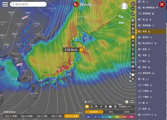
【#年越し寒波】目下の災害級の寒波は28日後半から30日前半にかけて緩むが,30日後半から年越し寒波が来そう.気象庁,欧州ECMWF,アメリカNOAAの予想が一致しているので確度が高い.31日は豪雪をもたらすJPCZ(日本海寒気団収束帯)が明瞭.1/4~5頃にも寒波が来そうで日本海側の山岳は大雪,大荒れ注意

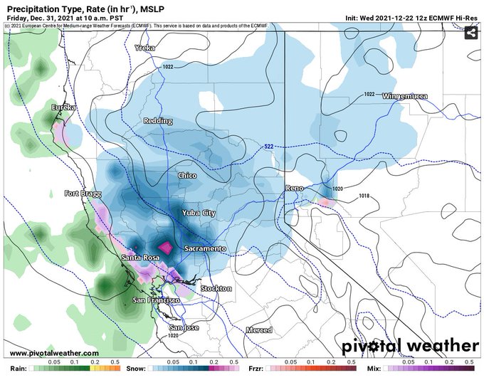

This is out in model fantasy land, but it's still shocking to see the ECMWF show a snowstorm sliding down the central valley to +/- sea level! It shows how cold this arctic air mass next week is going to be. @RobMayeda @Weather_West


A major pattern flip coming for the Easter, if you believe the deterministic ECMWF forecast.
[Charts by @PivotalWeather: https://t.co/w9jQLf7l9r]

Verification. ECMWF was closer to reality but not perfect either. https://t.co/yZ3FHtkQPf


Yesterday's ECMWF 12z run really reverse the polar night jet in the stratosphere, with -18 m/s (!) average zonal mean flow on 8 January 2021.


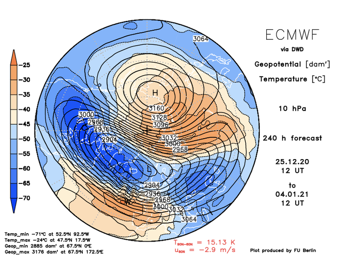


#成層圏突然昇温 に伴い北極域周辺の成層圏の西風が上空から東風に変わりつつあります。ベルリン自由大学が提供しているECMWFの予想図では、成層圏への波伝播の増大により高温域が北極まで達し、北緯60度10 hPaの高度で東風となる大昇温の基準に到達しています。
https://t.co/LHx3wgtpzV

ECMWF 10-day forecast for the stratosphere shows a reversal of the polar night jet stream (westerlies turn to easterlies).
This can lead to proper winter weather, if the reversal/deceleration of the westerlies descends also to the troposphere.


熱帯低気圧aの24日9時の各所予想
1枚目 WNI(予想天気図)
2枚目 ECMWF
3枚目 GFS
4枚目 GPV
気象庁の予報円見れば分かりますが、
どこに行くか分かりません。


【#台風10号 予定に警戒】ようやく気象庁のGSM(全球予報モデル)でも台風10号予定が発達する予想になってきたが、ECMWFが日本付近で最も低い911hPaを予想。さすがにモデルの過発達と思うが、海水温30℃超えに加えて台風9号が傾圧帯を北海道の北に押し上げるため、風のシアが小さく台風が温低化しにくい


気になる #台風10号 ですが、GFS(左)・ECMWF(右)予報共に少し西寄りに進路を取っています。(9/6(日)18時)
まだ発生すらしていない台風ですが、既に関西直撃等と話題になるのは備える意味でも良いことかと。
まだ2年前の台風のせいで、屋根がブルーシートの家が大阪市内は多いのです。