HarvardLibraryのTwitterイラスト検索結果。 15 件


Presenting a more expansive view of #TierradelFuego and its relation to the greater region of #Patagonia, here in an inset on a 1722(?) French chart of the Strait of Magellan, from the Atlantic to the Pacific, by Jean-Frédéric Bernard. #maps #HarvardLibrary

#Cincinnati, Ohio, on a #map from 1840(?), when paddle wheel steamboats plied the mighty Ohio River; drawn by B. Oertly and lithographed and published by Otto Onken. #HarvardLibrary

Making note of the striking morning assemblage this month in the eastern sky of the #planets known to Ptolemy; here on a plate of the comprehensible universe from the 1708 edition by Valk & Schenk of Cellarius' Harmonia Macrocosmica (1660). #maps #HarvardLibrary

The allure of the North continues, with an 1800 German #map of the #FaroeIslands (inset) and an interestingly compact #Iceland, by J.C.M. Reinecke and based upon a French survey map from 1776. #HarvardLibrary

And speaking of "Diana's Foresters" who roam under the light of the #Moon, here one fourth of an 1834 early lithographic print, the first to present the Moon in quadrants, and created by an amateur, Wilhelm Beer, and professional astronomer, Johann Mädler. #maps #HarvardLibrary

Another plate from the Buache/de L'Isle physical atlas Cartes et Tables de la Géographie Physique ou Naturelle; here, along with a map of the island Fernando de Noronha, is an 18th c. view of the sea floor near the equator between South America and Africa. #maps #HarvardLibrary

Johann Thomas Kraus' 18C #map of #Augsburg, 1740-1760 published in M. Seutter's Atlas novus. #HarvardLibrary High-res: https://t.co/c0TSqE6Yr7

#Alexandria, Egypt, 1400 years after the Greek astronomer/geographer/astrologer Claudius Ptolemy pondered the heavens and earth, here presenting the Mediterranean city's ancient ruins and grand contemporary edifices; from the Civitates Orbis Terrarum, 1575. #maps #HarvardLibrary
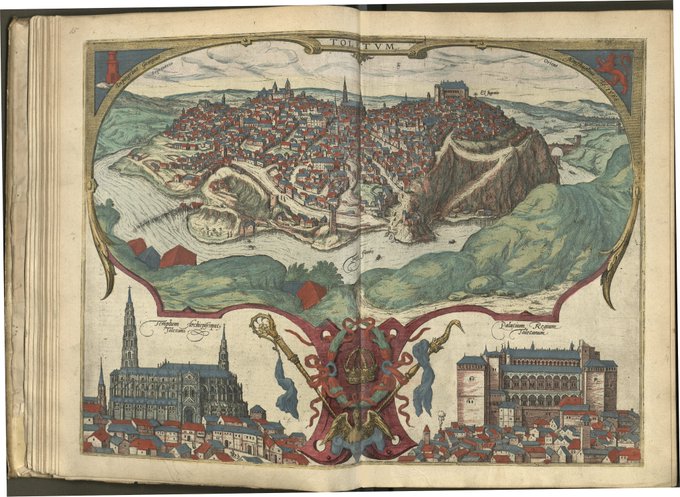
From the Americas to the Iberian Peninsula and the great "City of the Three Cultures" loftily settled above the Tagus River: #Toledo. From a 1566 drawing by Hoefnagel in the 1572 German edition of the Civitates, with buildings topped in vivid reds & blues #maps #HarvardLibrary

Gabriel Nicolaus Raspe's 1760s "Plan der Stadt und Festung Madrass in Ost-Indien"
https://t.co/n6x4d5qmaP
#Chennai #HarvardLibrary

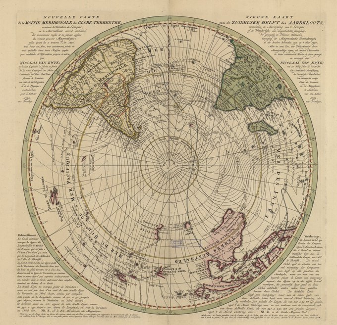
From the polar antipodes to the equator, 2 maps by van Ewyk, using isogonic lines to display the variation of the compass, "or the marvelous concatenated accord of regulated & never-ending movements of the living magnetic power; as we found them in 1750." #maps #HarvardLibrary

From Ptolemy's 2nd c. to Beatus' 8th c. (here in a 1929 facsimile by Konrad Miller). The tripartite world is encircled with water; East, where Paradise lay, is at the top of the #mappamundi; the Red Sea unmistakable in the South. A spatial-temporal worldview #maps #HarvardLibrary

A day late for #outofthisworld #wednesdaychallenge but I'm excited to do some printing in outer space! From Samuel M'Cullough's 1840, 8 sheet #map of the visible heavens. #harvardlibrary

For #WorldOceanDay and #libraryloveisloveislove, here's a #blue #map of the ocean around #Antarctica. It was published in 1898 to show "John Murray's proposed scheme for Antarctic exploration." #oceans #ocean #prideweek #HarvardLibrary


It's #RevoltingRhymes Day on Saturday! Create & illustrate hilarious verses at #JohnHarvardLibrary 2 to 3pm & #EastStreetLibrary 2 to 3:30pm