cyclonicのTwitterイラスト検索結果。 20 件
☀️#NFTGiveaway☀️
🏆2 Lucky Winners
🕰️48h
#NFTs:
1x Twirling Cyclonic Angel
1x Formation D'Aile D'Ange
✅To Enter:
1⃣ Follow @MetaArti1 @CyberTonesNFT
2⃣ Like & Retweet
3⃣ Tag 3 friends
☀️#NFTGiveaway☀️
🏆2 Lucky Winners
🕰️48h
#NFTs:
1x Twirling Cyclonic Angel
1x Formation D'Aile D'Ange
✅To Enter:
1⃣ Follow @MetaArti1 @CyberTonesNFT
2⃣ Like & Retweet
3⃣ Tag 3 friends
Painting CM for Chicken! Cyclonic Rift Alternative Art featuring his character and mess ups of mess ups
@zqevans I only had one try, but definitely thinking anything made in a non-DALL-E mode is *really* hard to prompt. could be wrong tho.
"psychedelic digital art portrait of a cyclonic orb-less faceless purple entity, with orange ears, opalescence, reflectance"
While #StormEunice will be exceptionally powerful, its evolution is classic.
Today's GFS 00z analysis shows the precursor, a deep mid-latitude trough over the North Atlantic.
Cyclonic vorticity advection ahead of the trough forces ascent and the formation of a surface cyclone.
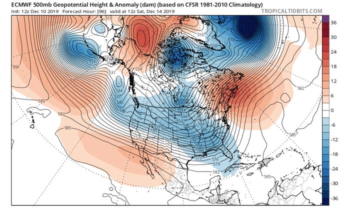
What's setting up at 500mb next 2-weeks is a quasi-stationary 4-wave pattern. Not ideal, esp. Mid-Atlantic on south. Textbook east-based La Niña / -PDO / -QBO trio creating feedback w/slow MJO progression and NPAC anticyclonic wave breaking. Result? Persistent west coast trough.
>Host game on spelltable
>Title: Casual Commander, power level 3-6
>Description: come play your precons and budget decks!
>This motherfucker shows up with Atraxa Super friends
>Chain veil, doubling season, mana crypt, force of will, cyclonic rift...
>Dude's deck is probably $3000
🏆Challenge Number 7⃣🏆
Name: Electric Dreams
Description: Holders of Zodiacs with an Electricity Elemental or Cyclonic Shielding property will be entered into a raffle for ETH prizes
Challenge Ends: Sunday, Aug 8th at Noon est (snapshot taken)
Info: https://t.co/qOhaf23Ga3
Got to be a player in the new Recontact system tonight for the first time ever!
Trapped in a deep sea research habitat during a cyclonic, while a swarm of bottom-dwelling coelenterates turned the substrate under the facility to quick-mud, into which we started sinking.
Quite an anomalous anticyclonic wave breaking event currently in the North Atlantic.
Acts like a precursor to the shift towards NAO+ regime.
https://t.co/kY0eOge2br
Cyclonic reaper
Commissioned for @spiritclashccg
RT are highly appreciated.
Follow for more
#grim #grimreaper #reaper #devil #skull #conceptualart #spirit #faust #scythe #illustration #illustrator #characterart #ArtistOnTwitter #commissionsopen #commissionart #dark #evil
Check out that cyclonic formation over BC. Four lovely images from METEOR M N2 produced around 9:30 AM PST here in #Vancouver with my WSat2 station.
#BCstorm
@bc_news_addict
@KMacTWN
@Cole_Beast
@WestSeaWx
@RandySmall
@Zach_wx
@OrcaBC101
@MMadryga
@MorganKIRO7
Sublette Opus
The grand finale of May 21st, part of a series of incredible sculpted mesocyclonic cells that dominated the prairie in West Kansas.
Captured w/ Fuji GFX50s
@ReedTimmerAccu @CReppWx @BrianBledsoe @NWSDodgeCity @PawneeStorm @FujifilmX_US #stormchasing @mejenwalton
The Trouble With Cyclonic Rift in Commander https://t.co/QbYSqYymWQ
A parade of aptly timed/placed cyclonic wave breakers like this over Atlantic Canada is a great way to set off a legit -NAO, esp when the tropospheric polar vortex is initially sitting in your backyard over northern Canada, ready to join in on the fun.
He is coming with a destructive cyclonic power to make his foes fear the rain... Uhum
I was boring then I made this Susano skin concept, I hope you like it!
@SMITEGame
#Smite #conceptart #Smiteconcept #fanart #DigitalArtist #skinconcept #smiteskin
While we wait for new art I thought I'd share some more MtG images from back in the day. "Cyclonic Rift"⚡🌀⚡ #mtg #magicthegathering
New artwork for sale! - "World Impressions - Cyclonic World" - http://t.co/lKGvI5FB6A @fineartamerica


