southgeorgiaのTwitterイラスト検索結果。 5 件
🔵Cloudy image of #Iceberg A-68E rotating CCW and following the SACCF north. A-68A hardly visible but almost stationary in the last 24h (slight move S) #SouthGeorgiaIsland🇬🇸 12 Jan 2021 #Copernicus🇪🇺 #Sentinel-3🛰️ Full-size ➡️ https://t.co/woVIBPqIKL #OpenData #scicomm
🔵Iceberg A-68A near #SouthGeorgiaIsland🇬🇸 (Dec 8 to 17) at the very edge of ocean areas less than 200 meters deep (pink), broken up on Dec 17 #Copernicus🇪🇺 #Sentinel🛰️ Full-size ➡️ https://t.co/QPy9FSTaz7 More ➡️ https://t.co/oj8sb1RPvs #OpenData #scicomm
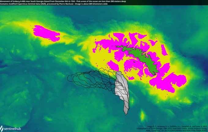
🔵Movement of Iceberg A-68A near #SouthGeorgiaIsland🇬🇸 from Dec 8 to 15 - Pink ocean areas are less than 200 meters deep, so possible areas for the iceberg to ground #Copernicus🛰️ #Sentinel🛰️ Full-size ➡️ https://t.co/ldZnfYrhxi More ➡️ https://t.co/oj8sb29qU2 #OpenData #scicomm
🔵Clouded image of Iceberg A-68A near #SouthGeorgiaIsland🇬🇸 (best position estimate outlined red, distance now less than 140 kilometers) 7 Dec 2020 #Copernicus🇪🇺 #Sentinel-3🛰️ Full-size ➡️ https://t.co/gAuoxpu6u7 🔴More images here ➡️ https://t.co/oj8sb29qU2 #OpenData #scicomm
Mapping incl #GIS and #satelliteimagery celebrated in new #SouthGeorgia #stamp issue @GIS4Schools @geogologue @The_GA @RGS_IBGschools @DaveAtCOGS @JamesGIS via @GovSGSSI +@BAS_News #exploration https://t.co/csrxuBjPO0


