OpenDataのTwitterイラスト検索結果。 36 件


Explore the History of Hydrographic Mapping through our #esri Spyglass #StoryMap! Compare beautiful historic maps around Ireland with recent #seabedmapping data.
#opendata
Check out the spyglass viewer here➜ https://t.co/AECnFH3vw6
@Dept_ECC @GeolSurvIE @MarineInst


2022 Ebbe Nielsen #Challenge seeks Open-data Innovations for #Biodiversity | Deadline: 14-Aug-22 https://t.co/VvfB1zyhVh By @GBIF #OpenData #innovation #Tech4All #technologyforgood


We’re delighted to announce that our hosted portal service is now open for applications from the GBIF network (open call, rolling basis, no deadline) to showcase data at national, regional, thematic and institutional scales.
📣 https://t.co/VUD67A9n6m
#opendata #biodiversity


#Satellite #photography of
#NorthSea Isle of #Spiekeroog
False color urban layer 2022 - Red urban areas
#Sentinel2 #Copernicus #remotesensing
@sentinel_hub
@CopernicusEU
@CopernicusLand
#QGIS #OpenData #EarthArt #EarthObservation #DataScience #dataviz #OpenScience

REMINDER: 4 months left to prep your #OpenData innovation for the 2022 Ebbe Nielsen Challenge!
Your share of €20,000 in prizes awaits in our annual incentive competition. Find inspiration from past winners:
https://t.co/eQfEN1EH07
Deadline: 14 Aug
https://t.co/DCNiH6ofMR


🔵 #Wangerooge and Wadden Sea tidal flats, North Sea, #Germany🇩🇪 14 Sep 2021 #Copernicus🇪🇺 #Sentinel-2🛰. Try out the @sentinel_hub EO Browser and easily explore the Earth, even on mobile devices! #RemoteSensing #OpenData #scicomm


#30DayMapChallenge 2021 day 1: ‘1 dot = 1 person’: creative shading for #population data, using the @QGIS geometry generators. #OpenData @HelsinkiUni @KumpulaScience @GeoHelsinkiUni, map by @chrxf, using #OpenData from @Tilastokeskus and @helsinki (1/x)


The low lying coastal geography of the region makes the Mekong River Delta vulnerable to climate change & sea-level rise, and to related issues such as coastal erosion & saltwater intrusion
It can be monitored with our #OpenData
#Sentinel2 🇪🇺🛰️ image processed by @i_ameztoy


🟠 Fires🔥 and smoke plumes in the #SakhaRepublic, #Siberia, #Russia🇷🇺 8 September 2021 #Copernicus🇪🇺 #Sentinel-3🛰️ Full-size ➡️ https://t.co/bLSY7k6tZ2 + https://t.co/1N7T4KrlsC #OpenData #scicomm #wildfire #СибирьГориТ Images are about 645 kilometers wide

🟠 #Fire🔥 120 kilometers SE of #Ambarchik, within the #ArcticCircle❄️, #Chukotka, #Russia🇷🇺 12 August 2021 #Copernicus🇪🇺 #Sentinel-2🛰️ Full-size ➡️ https://t.co/WNfq4HdQm0 #OpenData #scicomm #wildfire #СибирьГорит #Arctic #Siberia


 ⭕️ #Siberia is burning. Countless big fires🔥 and smoke plumes all over the #SakhaRepublic in #Russia🇷🇺 #RemoteSensing #OpenData #scicomm #wildfire #Yakutia #СибирьГорит #AirQuality More images here https://t.co/GYa29PJvYk https://t.co/Xda1HmUywm

🟠 Enormous #fires🔥 and smoke plumes NW of #Yakutsk in the #SakhaRepublic, #Siberia, #Russia🇷🇺 28 July 2021 #Copernicus🇪🇺 #Sentinel-2🛰️ Full-size ➡️ https://t.co/zraCSUMDUT #RemoteSensing #OpenData #scicomm #wildfire #СибирьГорит Image is about 124 km wide
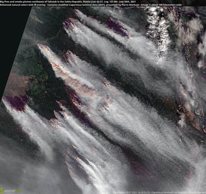
🟠 Big fires🔥 and smoke plumes NW of Yakutsk in the #SakhaRepublic, #Siberia, #Russia🇷🇺 18 July 2021 #Copernicus🇪🇺 #Sentinel-2🛰️ Full-size ➡️ https://t.co/zQ2lrxf0jI #RemoteSensing #OpenData #scicomm #wildfire #Якутск Image is about 190 km wide More ➡️ https://t.co/2oHsOrcNA4
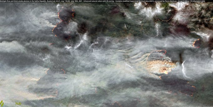
🟠 Multiple fires🔥 and thick smoke plumes in the #SakhaRepublic, #Siberia, #Russia🇷🇺 18 July 2021 #Copernicus🇪🇺 #Sentinel-2🛰️ Full-size ➡️ https://t.co/oWCjXW6p87 #RemoteSensing #OpenData #scicomm #wildfire Image is about 176 kilometers wide
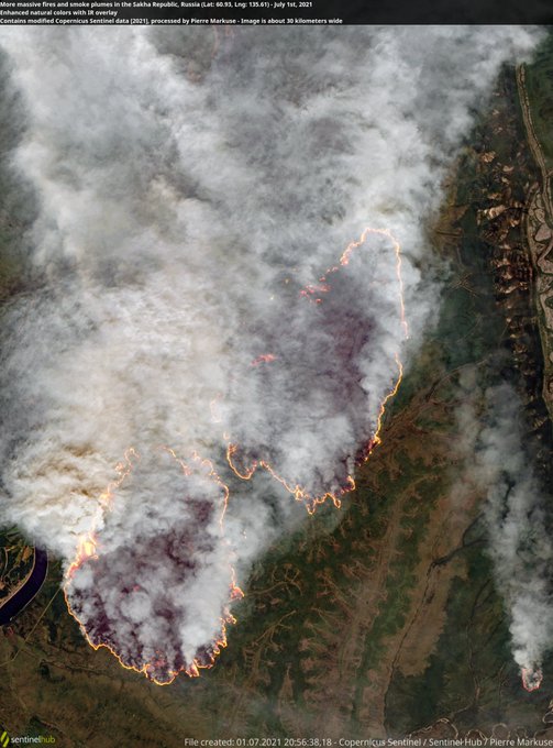
🟠 More massive fires🔥 and smoke plumes in the #SakhaRepublic, #Siberia, #Russia🇷🇺 1 July 2021 #Copernicus🇪🇺 #Sentinel-2🛰️ Full-size ➡️ https://t.co/suXPrIbbV8 #RemoteSensing #OpenData #scicomm #wildfire


Maps and the park: how to use OS OpenData with
@Esri's ArcGIS Pro, and create your own map and print it on to canvas...........https://t.co/ZJMLcgcUcZ #maps (Image: OS Data)

🔵Cloudy image of #Iceberg A-68E rotating CCW and following the SACCF north. A-68A hardly visible but almost stationary in the last 24h (slight move S) #SouthGeorgiaIsland🇬🇸 12 Jan 2021 #Copernicus🇪🇺 #Sentinel-3🛰️ Full-size ➡️ https://t.co/woVIBPqIKL #OpenData #scicomm


It's @Wikipedia's 20th birthday on 15 January 2021! 🌐
"celebrating how humans made Wikipedia what it is, and only humans can help sustain & grow it. We are celebrating 20 years human!"
Community coordination page: https://t.co/jKFR7b99hM
#OpenData #OpenScience #FreeKnowledge

🔵Iceberg A-68A near #SouthGeorgiaIsland🇬🇸 (Dec 8 to 17) at the very edge of ocean areas less than 200 meters deep (pink), broken up on Dec 17 #Copernicus🇪🇺 #Sentinel🛰️ Full-size ➡️ https://t.co/QPy9FSTaz7 More ➡️ https://t.co/oj8sb1RPvs #OpenData #scicomm


Anyone been out exploring the @USGSTNM #3DEP #lidar available in OpenTopography? One of our team just noticed that Devils Tower National Monument is covered in a recently released dataset (https://t.co/jGnFKVCn8T). Images produced w/ OT browser-based tools. #opendata #devilstower