
NLS Map Collectionsさんのイラストまとめ
@natlibscotmapsFollow @natlibscotmapsさんをフォローする
フォロー数:1134 フォロワー数:16168


This 1862 map shows the very beginnings of Antarctic exploration. That point James Weddell reached in 1823 was the farthest south a ship had ever been. 88 years later - #otd - Amundsen became the first person to reach the South Pole.
https://t.co/pypZzd7wuc
#AdventWorldMap day 14


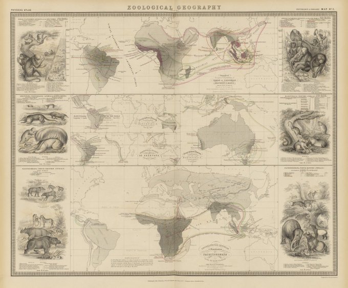
On #InternationalAnimalRightsDay, details from an 1848 Zoological Map. Published 10 years before Darwin’s ‘On the Origin of the Species’, they show what Europeans knew of the world's fauna in the mid 19th century.
Day 10 of our #AdventWorldMap - Africa
https://t.co/EREQ1kefvA


Brrrr... Storm Caroline has arrived! 💨 Day 7 and we’re opening the arctic door on our #AdventWorldMap, with a detail of Bartholomew’s map - Storm Tracks & Frequency from his 1920 world atlas.
See these colourful climate #maps at https://t.co/GY1jGxgvhu


For Day 5 of our #AdventWorldMap - and #TravelTuesday - a detail of the Indian Ocean from this 1923 map of the world's Sailing Ship Routes (note how routes change according to the time of year).
https://t.co/4E8iS6FkZp


#AdventWorldMap day 1. Everyone loves reindeers at Christmas! This 1937 Map shows the extent of reindeer herding from Alaska to Siberia. Despite differences in landscapes & cultures it’s still practiced almost identically wherever it is found.
https://t.co/wN3gMcfoEV

Mapping the Borders launches *tomorrow* with an afternoon of talks. Hear academics & artists, whose work brings new perspectives to the #Scottish Borders.
Sat 18 Nov (2-5:30pm). MacArts, Bridge Street, #Galashiels.
https://t.co/TmV2I5qfH0

Ever wonder what abbreviations on old O.S. maps stand for? This list should help... https://t.co/uPe6hVzms7
#NationalMapReadingWeek


Explore the secret lives of animals with these marvelous maps https://t.co/MMHosXvPGO via @SmithsonianMag

We bet many kettles were boiled #otd 1952, when it was announced that tea would no longer be rationed.
Map of tea districts of India, 1897

Five paper artists doing magical things with old #maps... https://t.co/yFkGDATgHl via @scoopit
#mapsinart