
Simon Kuestenmacherさんのイラストまとめ
@simongerman600Follow @simongerman600さんをフォローする
フォロー数:220049 フォロワー数:260245


An accurate view of ancient Roman Carthage, a city that was built by Julius Caesar on the site of the previously destroyed Punic capital. Source: https://t.co/CCVoBQ2riv

The famous Rostocker Pfeilstorch (arrow storck) from 1822 demonstrated that birds migrated away from Europe in winter to Africa rather than hibernating or changing form (!) in winter. Now common knowledge back then a theory in need of proof. Source: https://t.co/CbOLmySEH6
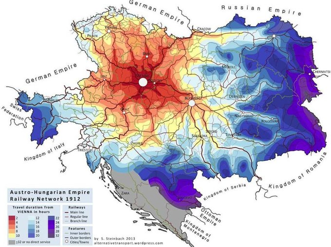
Map shows the travel time along the Austro-Hungarian Empire’s railway network back in 1912. Source: https://t.co/wP0OMhPfFq

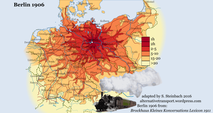
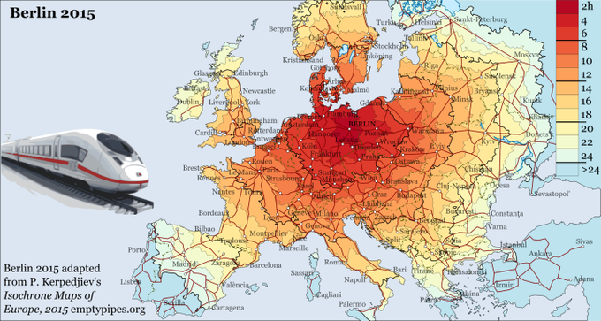
Isochrone map shows travel times from Berlin in 1819 (by coach), 1906 (by steam train) and 2015 (by fast train). Source: https://t.co/xQVPigsPSs

Map shows all the countries mentioned or referred in the Bible. Hadn’t seen something like this before and I love it! Source: https://t.co/33qb73ZSvd

Great use of publicly available but not obvious data. Dominant color of each country as seen from space. Uses the Google Maps API and k-means clustering with Python to calculate the dominant color for each geography. Source: https://t.co/73DkZY2tq8

This will be hotly debated! Do shoes have to be removed in the home? Based on my time living in Germany, US and Australia I’d say these three countries are correctly displayed on the map. Is your country correct? Source: https://t.co/VOttA2x79h

Map shows the population density of Russia and is labelled with US states that similar in density. Source: https://t.co/fUu3mGkMUB

Time for another wonderful animal map. This time we look Brown Bear sightings across Europe. Source: https://t.co/a90YlCLEGw

Global air travel flow map (2018). This is essentially a combination of a population density and a wealth map... Source: https://t.co/iGIspxEoSg