OpenDataのTwitterイラスト検索結果。 36 件中 2ページ目

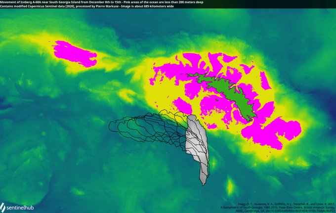
🔵Movement of Iceberg A-68A near #SouthGeorgiaIsland🇬🇸 from Dec 8 to 15 - Pink ocean areas are less than 200 meters deep, so possible areas for the iceberg to ground #Copernicus🛰️ #Sentinel🛰️ Full-size ➡️ https://t.co/ldZnfYrhxi More ➡️ https://t.co/oj8sb29qU2 #OpenData #scicomm

🔵Clouded image of Iceberg A-68A near #SouthGeorgiaIsland🇬🇸 (best position estimate outlined red, distance now less than 140 kilometers) 7 Dec 2020 #Copernicus🇪🇺 #Sentinel-3🛰️ Full-size ➡️ https://t.co/gAuoxpu6u7 🔴More images here ➡️ https://t.co/oj8sb29qU2 #OpenData #scicomm


☝️ #EOBrowser #update: Merging data from the same! #satellite 🛰is now possible
#DIY ➡️Check out our blog post on #DataFusion to get inspired & learn how to combine different satellites into one visualization🖼. ➡️https://t.co/vibdzJhvTB
#OpenData #Coperniscus #EarthObservation

🟠 #Wildfires🔥 and smoke plumes in #California, #USA🇺🇸 24 August 2020 #Copernicus #Sentinel-3🛰️ Full-size ➡️ https://t.co/0BM7vOjIgY #scicomm #OpenData #CaliforniaFires #CALFIRE #LNULightningComplex #SCULightningComplex Image is 380 km wide! More ➡️ https://t.co/TH0LNZhqvb

🟠 Countless #wildfires🔥 in the #SakhaRepublic, #Siberia, #Russia🇷🇺 with a total burnt area over 20,000 km² 26 July 2020 #Aqua🛰️ #MODIS Full-size ➡️ https://t.co/ajhBymJGdf #RemoteSensing #scicomm #OpenData #Arctic #ArcticCircle 🔴 Image is showing an area of about 240 by 600 km https://t.co/rTFfOyKrM8


Continuing extreme daily total #Arctic #wildfire intensity & smoke emissions in latest #CopernicusAtmosphere Monitoring Service GFAS #opendata➡️ https://t.co/eb31VObkdM. @JPSSProgram #VIIRS🛰️ imagery shows similar picture to previous days https://t.co/mBoztpE0Zx #ArcticFires


🟠 A #wildfire🔥 in the #SakhaRepublic, within the #ArcticCircle, #Siberia, #Russia🇷🇺 24 July 2020 #Copernicus #Sentinel-2🛰️ Full-size ➡️ https://t.co/PGH2Wni1sD + https://t.co/egfmkKpOgp #RemoteSensing #scicomm #OpenData Image is 29 kilometers wide!


Need to go somewhere?
Thanks to #opendata like this:
https://t.co/ZwL8QepQzJ
from the likes of @Wellington_NZ @porirua_city @PNCityCouncil @MarlDistCouncil @GDC_updates @Taupo_DC @TararuaDistrict & @haurakiTrail
We have useful apps like @campermate


🟠 Another big and smoky #Arctic #wildfire🔥 in #Siberia thanks to the #ArcticHeatwave. #Russia🇷🇺 20 June 2020 #Copernicus #Sentinel-2🛰️ Full-size ➡️ https://t.co/zRgVg72fhr https://t.co/zSObH5Qypz #RemoteSensing #OpenData #scicomm Image is 37 km wide ➡️ https://t.co/7ktCCijPJN


Despite some bothering clouds @CopernicusEU #Sentinel3 water leaving reflectance showed again the beauty of #blacksea swirls & colours on May 15 #Georgia #Turkey #opendata @ESA_EO @EUDelegationTur @stracma @aida_alvera @kryosat @eumetsat @CMEMS_EU @PlymouthMarine @EU_ENV @BBCAmos


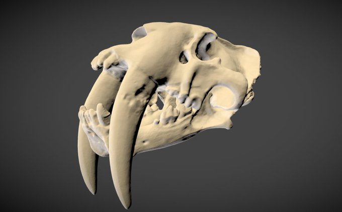
It's #FossilFriday and if you want to see some really cool 3D models check out our new EddyLab @Sketchfab account 🎉 https://t.co/Dhv276RvZU Vertebrates, invertebrates and even pine cones ! and (almost) all these beauties are downloadable #OpenAccess #OpenData #scicomm 😍

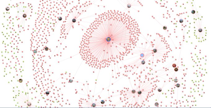

#Singapore contact tracing (using TraceTogether) & testing system provides extensive publicly available information. Network graph of cases & contacts. #covid19 #OpenData
https://t.co/rksACpbh4G
@RyanInstitute @nuigalway


mHealth Project to Crowdsource Consumer Data for Coronavirus Research
https://t.co/nZlOXE73RH
#mhealth #COVID19 #medicalresearch #opendata


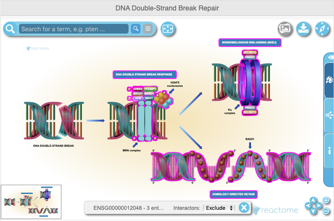
Did you know #Ensembl integrates data and displays from other #DataResources?
E.g. for #BRCA1:
@ExpressionAtlas https://t.co/vCtLcRp1T9
@PDBeurope https://t.co/fgXXdNzqY9
@reactome https://t.co/LlSWNP7Gv9
#Ensembltraining #OpenData @emblebi


Viedma Glacier in the Southern Patagonian Ice Field
Not only a nice postcard from #space, but #OpenData for monitoring
A comparison between #Sentinel2 🇪🇺🛰images acquired at the same time of the year (March) in 2016 and 2019 show a significant retreat of the terminus
See tweet ⬇


Open Data impact #2 : journée d'ateliers pour explorer les défis de l'open data. Mercredi prochain 4 juillet chez Mozilla Paris : https://t.co/swUElsaJIh #opendata