convectionのTwitterイラスト検索結果。 37 件中 2ページ目

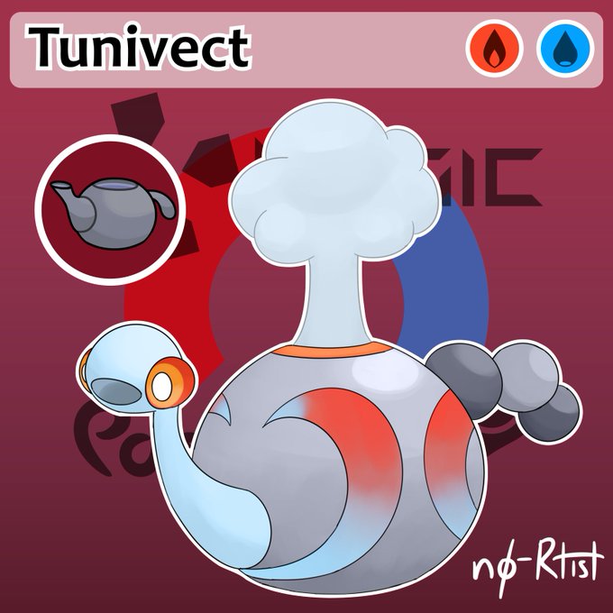
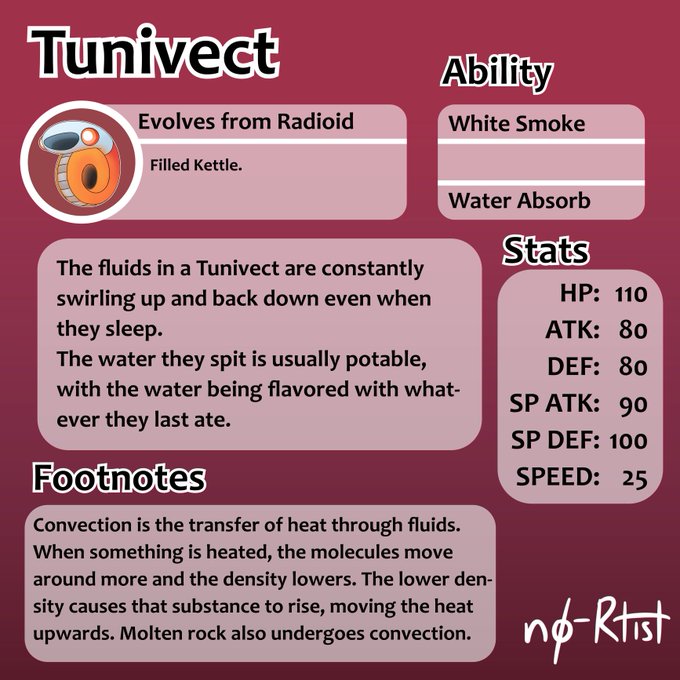

Tunivect (Fire/Water): Convection is the transfer of heat through fluid movement. When a fluid is heated, they lose density and rise.
#PokemonSwordShield #Pokemon #fakemon #ArtistOnTwitter #science #physics #education #convection #cooking #kettle #tunicate


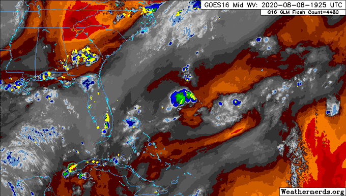
Satellite image currently indicates deep convection currently offshore the south coast of Jamaica. Sections of Jamaica should continue to receive showers that could be heavy enough to trigger flash flooding tonight into tomorrow. If you must go out tomorrow bring your umbrella.


The large-scale pattern late this week consists of a strengthening jet streak over the SE US, which means upper-level divergence over southern GOM and NW Caribbean that favors convection. With a tropical wave entering the region simultaneously, need to watch for storm formation.


@pppapin @AndyHazelton @ToddKimberlain @webberweather Part of my thinking is that there's dry air to the N that might be getting entrained in the N side of the storm, as well as convection being ripped apart by the interaction, which is causing the one-sided favorability (given the opposite is occurring in the Caribbean side)

Hearing some talk about ex-#94L this afternoon. The closed, relatively well defined LLC has gotten convection, bringing it closer to TC status. Some dry air lurks nearby but there's a chance of sneaky development of it can maintain the convection

Concerning trends with #Isaias tonight.
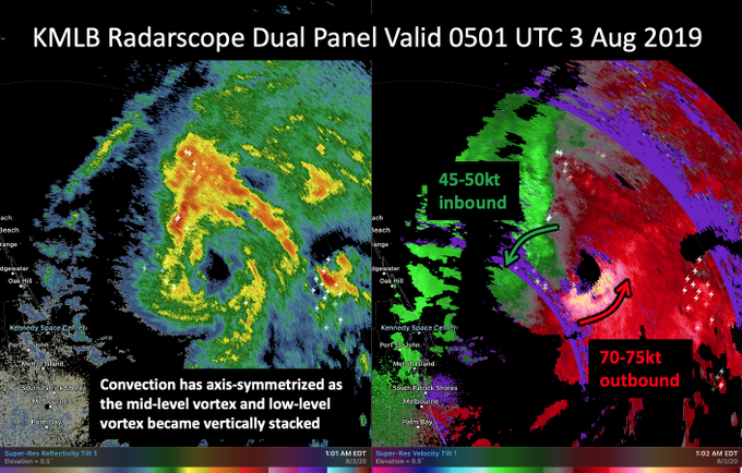
The earlier radar hole now appears to becoming a bonafide eyewall with significant inbound & outbound velocities on KMLB radar. The low & mid-level center now appear aligned as convection axis-symmeterizes.


Won’t lie, the HWRF did a fairly good job at forecasting this convection burst, in fact, it looks almost like a spitting image tho smaller. Let’s see how it performs on the rest of the night.

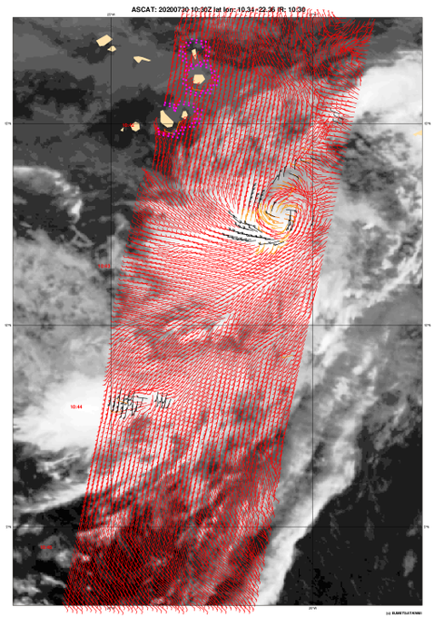

As a couple other mentioned, this wave to the SE of the Cabo Verde islands honestly looks like it could be very close to being a TD already. Convection has been asymmetric but persistent, and ASCAT shows a solid circulation with 30kt winds. Will be short-lived whatever it is.


Convection is going crazy this evening during diurnal minimum. Oh boy..

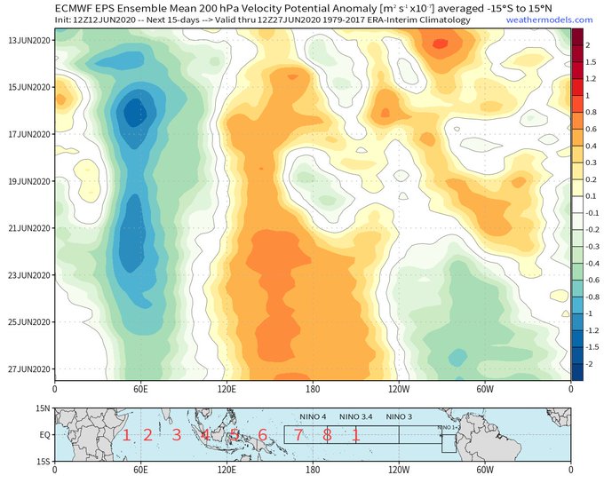
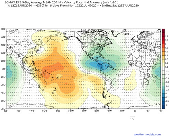
Fwiw, the EPS is consistently hinting at a massive uptick in E Pacific & W Atlantic convection near the end of June. This may result in a burst of NE Pacific tropical cyclones & perhaps a more favorable subseasonal state for tropical cyclogenesis in the Atlantic by early July.


On the stability of projection-based model order reduction for convection-dominated lamin... https://t.co/0ieeOx462B


In Food Wars! S3 ep.10, Kurokiba vs Kusunoki begins.
The theme is salmon!
With the convection oven and other cutting edge cookery equipments, Kusunoki cooks up slow cooked salmon flame!
Will Kurokiba’s Coulibiac good enough to counter that!?
#shokugeki_anime https://t.co/lp9G2esnVX


clouds r lookin soggy. plz drip,, iz 2 hawt need dat convection coolant
radiator radiator in da sky
leak on me or i wil die


056- Thermoni, Flying/Electric. With its signature move Convection, Thermoni releases an immense amount of electrical energy and maxes out its speed stat, ⛈️#fakemon


Pris wishes you all a hefty, juicy meal, and to please pass the salt.
*eyeing my empty convection oven and dreaming of assorted roast meats ( ´ ꒳`)*
#illustration #elf #meal

