BathymetryのTwitterイラスト検索結果。 8 件


#30DayMapChallenge Day 26 Islands: Archipelago of Madison
What if, instead of a city surround by lakes, Madison was a chain of islands? Inverted lake bathymetry from @WiscLimnology + mapped using #aerialod #gischat


The overlay of @CopernicusEU #sentinel1 🛰️ over this improved bathymetry by @BAS_News shows how close iceberg #A68a has approached the shallow ocean waters near South Georgia Islands 🇬🇸. Knowing that #A68a reaches ~200 m below sea level, it is very close to grounding.

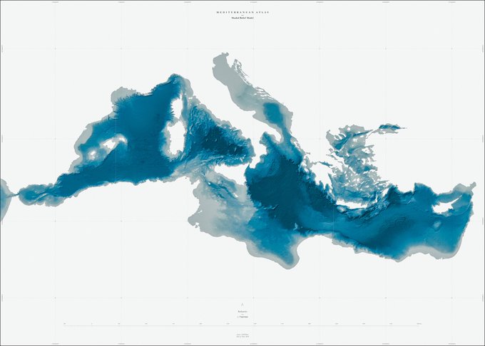


What a gorgeous bathymetry map of the Mediterranean Sea. The map makes is tricky to spot the coastline. Thank god Italy is easy to spot. (Bathymetry is the study of underwater depth of ocean floors or lake floors.) Source: https://t.co/X1bQiCWFuq


Inspired by #NALMS2019 and (@ucfagls's excellent post about it), I wrote up a small tutorial about how to do bathymetry/volume calculations using #rstats! Koodos to @NALMStweets for putting together a fantastic conference! https://t.co/jBRzUXH3zx


It's also #WorldHydrographyDay 🌊Hydrography is the #science of #surveying and charting seas, lakes, rivers and more. Theme for 2018 is Bathymetry. Map by the Royal Geographical Society using #data compiled by Dr. John Murray. Pub. 1899 💦 More sea charts: https://t.co/CpVuXmDeGS


Ever wondered why the waters of Ramsey Sound do wha they do? This bathymetry image gives a bit of a clue.


#INFOMAR seabed survey 2017 progress @CHERISHproj #RVKeary St. Patrick's Island, Skerries #Dublin #Bathymetry #Backscatter