gischatのTwitterイラスト検索結果。 10 件


🗺️A Map Showing Terrain Model of Mt.Rainier 🏔️( Pierce County, Washington, U.S🇺🇸) Data source from @OpenTopography (USGS10m) #MtRainier #gischat #cartography #dataviz #QGIS #Blender3d #DataVisualization #Geospatial


#gischat, happy Valentine's Day. Will you be my valentine?
If you want me to be your valentine, you need to like one of the following: #GIS, #IT, #ComputerScience, #Programming, #Mathematics, #Engineering, #Data, #DataAnalytics #Science, #Writing, #Animation, #Tutoring,… https://t.co/UsthSxanfY


#30DayMapChallenge Day 26 Islands: Archipelago of Madison
What if, instead of a city surround by lakes, Madison was a chain of islands? Inverted lake bathymetry from @WiscLimnology + mapped using #aerialod #gischat

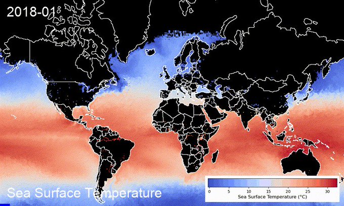
Happy New Year🎆 You can now create sea surface temperature timelapse with a colorbar using the #streamlit web app in <60 seconds 👇
App: https://t.co/LpcKK9yI6p
GitHub: https://t.co/ufznWiTnvs
#EarthEngine #geemap #eochat #gischat #oceancolor #dataviz #geospatial


One of the stranger maps I've made!
Major props if you can guess what it shows 🙃 #gischat


#gischat I need some outside input! What do you prefer--state lines or no state lines?


🎨 I mapped my neighbordhood in the style of an artist
👉Can you guess who❓
🔴No SVG
🎁Only OSM Data
🌟Only Geometry Generators (and @qgis)
Location : https://t.co/auHtgw1moj
#OpenStreetMap #madewithqgis #gischat #QGIS #cartography


@MicheleTobias #gischat! behold my first slide for a talk for the Eurocarto conference hehe the talk is much more serious than the first slide makes it seem 😁 anybody joining for the conference? It's online and it's full of mapping enthusiasts.