Sentinel-2のTwitterイラスト検索結果。 18 件


Big wildfires near Yellowknife, Canada, seen yesterday by the #Sentinel-2 satellite.
Data: @CopernicusEU
Processing: @sentinel_hub using @Pierre_Markuse's fire script.

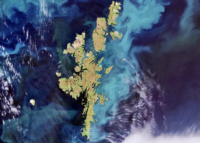
Shetlands Islands as seen from Space. Archipelago in the Northern Isles of Scotland are featured in this Copernicus Sentinel-2 Satellite image (SpaceRef) 🚀🛰📡🔭🌍🏴💫✨✨

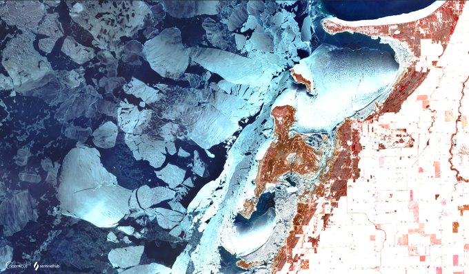
This 🤩 image of crumbled ice 🧊⛸️ along the shoreline in #SaginawBay, #Michigan was inspired by @kosmi64833127's beautiful find!
🛰️ Sentinel-2 L2A
🖌️ modified False Color Composite
🖼️ See our gallery for more https://t.co/yqeEpNbMgF
👀 #EOBrowser ➡️ https://t.co/0T2orPmmWd


🔵 #Wangerooge and Wadden Sea tidal flats, North Sea, #Germany🇩🇪 14 Sep 2021 #Copernicus🇪🇺 #Sentinel-2🛰. Try out the @sentinel_hub EO Browser and easily explore the Earth, even on mobile devices! #RemoteSensing #OpenData #scicomm


Zalew Szczeciński (Szczecin Lagoon) in Poland.
@CopernicusEU #Sentinel-2🛰️image acquired today (27 December)


One of the sickest Sentinel-2 visualizations I have ever seen from @erindataviz. Full write up with code snippets and everything here: https://t.co/Aobbi7Cucb


#Copernicus #Sentinel 🇪🇺🛰️
In orbit Sentinel missions help us find answers to humanity's global challenges
Sentinel-1 ▫️ day/night #radar vision
Sentinel-2 ▫️ #land monitoring
Sentinel-3 ▫️ #ocean & #climate
Sentinel-5P ▫️ #AirQuality
Sentinel-6 Michael Freilich ▫️ #sea-level


🟠 #Fire🔥 120 kilometers SE of #Ambarchik, within the #ArcticCircle❄️, #Chukotka, #Russia🇷🇺 12 August 2021 #Copernicus🇪🇺 #Sentinel-2🛰️ Full-size ➡️ https://t.co/WNfq4HdQm0 #OpenData #scicomm #wildfire #СибирьГорит #Arctic #Siberia

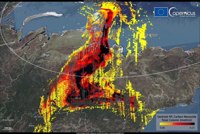
🟠 Enormous #fires🔥 and smoke plumes NW of #Yakutsk in the #SakhaRepublic, #Siberia, #Russia🇷🇺 28 July 2021 #Copernicus🇪🇺 #Sentinel-2🛰️ Full-size ➡️ https://t.co/zraCSUMDUT #RemoteSensing #OpenData #scicomm #wildfire #СибирьГорит Image is about 124 km wide
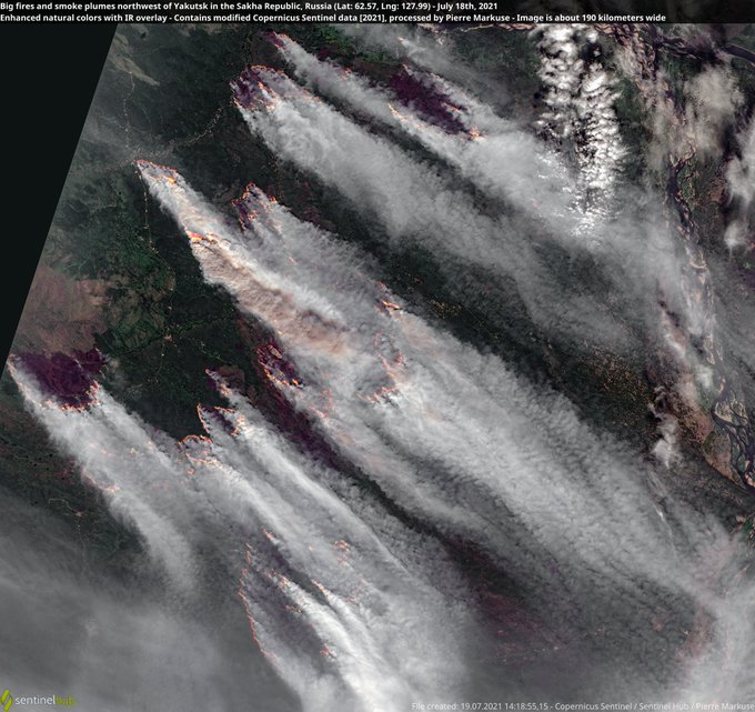
🟠 Big fires🔥 and smoke plumes NW of Yakutsk in the #SakhaRepublic, #Siberia, #Russia🇷🇺 18 July 2021 #Copernicus🇪🇺 #Sentinel-2🛰️ Full-size ➡️ https://t.co/zQ2lrxf0jI #RemoteSensing #OpenData #scicomm #wildfire #Якутск Image is about 190 km wide More ➡️ https://t.co/2oHsOrcNA4
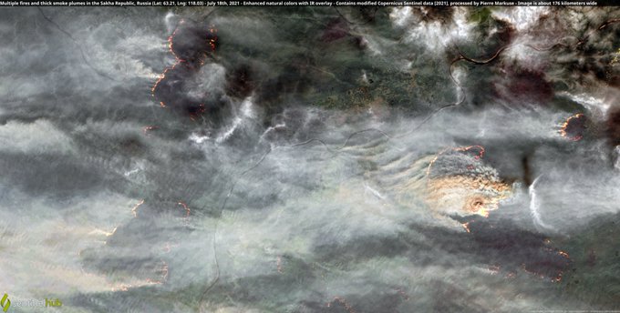
🟠 Multiple fires🔥 and thick smoke plumes in the #SakhaRepublic, #Siberia, #Russia🇷🇺 18 July 2021 #Copernicus🇪🇺 #Sentinel-2🛰️ Full-size ➡️ https://t.co/oWCjXW6p87 #RemoteSensing #OpenData #scicomm #wildfire Image is about 176 kilometers wide
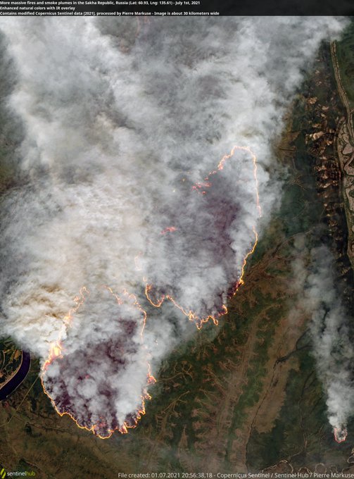
🟠 More massive fires🔥 and smoke plumes in the #SakhaRepublic, #Siberia, #Russia🇷🇺 1 July 2021 #Copernicus🇪🇺 #Sentinel-2🛰️ Full-size ➡️ https://t.co/suXPrIbbV8 #RemoteSensing #OpenData #scicomm #wildfire


🔴Check some cool examples on how to fuse various satellite missions' data to look through clouds, generate NDVI from SAR, pan-sharpen daily Sentinel-3 imagery with weekly Sentinel-2 and more.
As usual, all processing scripts are open-source.
https://t.co/9QGUStwIQG


🟠 A #wildfire🔥 in the #SakhaRepublic, within the #ArcticCircle, #Siberia, #Russia🇷🇺 24 July 2020 #Copernicus #Sentinel-2🛰️ Full-size ➡️ https://t.co/PGH2Wni1sD + https://t.co/egfmkKpOgp #RemoteSensing #scicomm #OpenData Image is 29 kilometers wide!


🟠 Another big and smoky #Arctic #wildfire🔥 in #Siberia thanks to the #ArcticHeatwave. #Russia🇷🇺 20 June 2020 #Copernicus #Sentinel-2🛰️ Full-size ➡️ https://t.co/zRgVg72fhr https://t.co/zSObH5Qypz #RemoteSensing #OpenData #scicomm Image is 37 km wide ➡️ https://t.co/7ktCCijPJN


It looks like the March 23 anomaly of the Astra rocket at Kodiak Launch Complex was pretty large, there's a bunch of scarring around the pad that wasn't there before 1:40 PM March 23 Alaska time. Sentinel-2 L1C false color. @DJSnM @SciGuySpace


Not a painting, but the actual water-color of a plankton bloom in the Barents Sea, imaged by the Sentinel-2A.