Before/during the #RollingFork/#SilverCity Mississippi #EF4 tornado, pulsing cold overshooting tops were seen in 1-minute @NOAASatellites #GOES16/#GOESeast Infrared images - with a notable #GLM #lightning jump just before the event: https://t.co/vDlVABynZ1 @NWSJacksonMS #MSwx
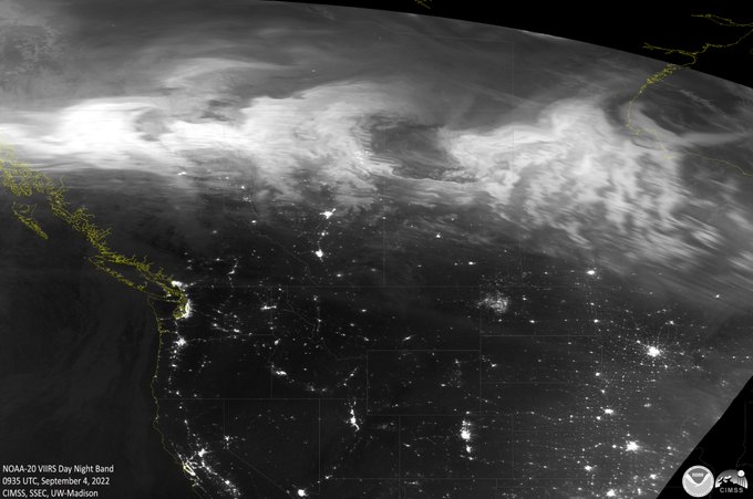
Two striking views of the North America #AuroraBorealis overnight as seen from space. These monochromatic images capture the celestial phenomena during a moment in time (during a satellite overpass) but clearly convey motion. Enjoy!
Total Precipitable Water data from satellite microwave sensors shows significant tropical moisture wrapping into Subtropical Storm #Nicole while a long #AtmosphericRiver stretches toward #Alaska. https://t.co/RXmC5iVPZo
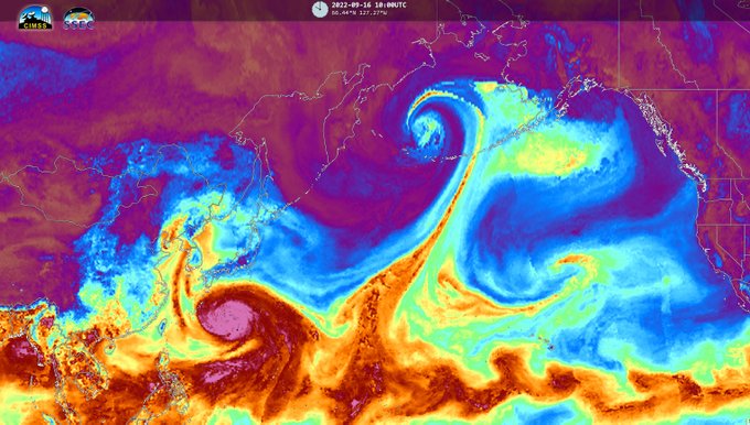
The remnants of TS #Merbok have entered the Bering Sea pulling an impressive #AtmosphericRiver north from the tropics. Strong winds (potentially hurricane force) high surf, coastal flooding and heavy rains will impact southern Alaska this weekend. https://t.co/SGeztR6wfo #AKwx
The #AuroraBorealis was ON FIRE last night and every satellite overpass captured a stunning display of the dancing lights from space. These 3 images were acquired by the #NOAA20 satellite. https://t.co/N94utqlp7f
Typhoon #Hinnamnor has weakened considerably swirling between Taiwan and the northern Philippines with impressive convective bursts around a ragged eye. Heavy rains are expected as the system moves northward, but landfall is still not likely. https://t.co/0LwJk0LIqE
Trans-Pacific moisture is headed toward British Columbia Canada and the U.S. states of Washington and Oregon this weekend. #GOESWest water vapor is tracking the impressive flow as it feeds into a Low pressure storm system. Updates at https://t.co/0L306T3BBa #BCstorm #WAwx #ORwx
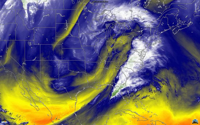
This massive mid-latitude cyclone has wreaked havoc for millions while plodding eastward. The Watches, Warnings and damage have been relentless, and sadly, even deadly. This #GOESEast loop pairs Water Vapor with True Color Visible imagery to convey the power of the huge system.
While you were sleeping - our atmosphere was on the move! Greens, whites and blues in this #GOESEast water vapor loop reveals moisture transport overnight into a winter storm over #NewEngland & rainy weather in the Pacific Northwest. Plus a cool gyre over the Atlantic Ocean.


