datavisualizationのTwitterイラスト検索結果。 64 件中 2ページ目
Contour line map showing the topography of Ecuador.
This map was made with #Python. Comment and let me know which country I should make next! #Data #DataScience #Datavisualization #DataScientist #Ecuador #Geography
Contour line map showing the topography of Greece.
This map was made with #Python. I converted a DEM to contour lines and then used a fun colourmap. #Data #DataScience #Datavisualization #DataScientist #Greece #Geography
At least 300 people have been killed since the beginning of protests in Iran including at least 47 children and teenagers. Source: Human Rights Activists News Agency
#MahsaAmini #WomanLifeFreedom #IranRevolution #datavisualization #dataviz #infographic
"Hypnose" Mathematical Art Series exploring the 'magical' number PI (3.14) which turns lines into curves and never ends.
#genart #generativeart #aiart #digitala #aiart #creativecoding #aiartwok #aiartworks #nft #javascript #aiartcommunity #mathart #dataart #datavisualization
A data visualization project I worked on last year was longlisted for the 'Information is Beautiful Awards' @infobeautyaward 😊😊😊!
https://t.co/ZKH2gQoBgA
#dataviz #Datavisualization
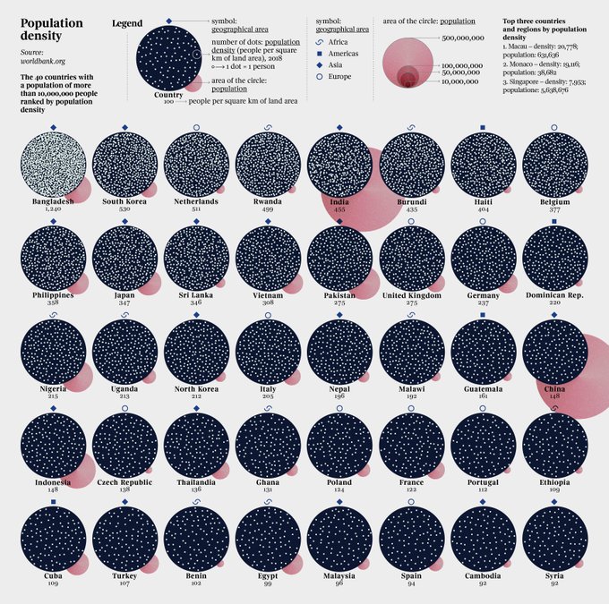
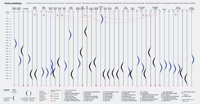
In the last weeks our project Key Workers was selected for a STARTS Prize @arselectronica 2022 Nomination and my #dataviz for @la_lettura made it into the @dezeen Awards Design Longlist! Thank you for these recognitions to projects I care so much about.
#DataVisualization
ジブリ作品の興行収入
1. 千と千尋の神隠し: 316.8億円
2. もののけ姫: 201.8億円
3. ハウルの動く城: 196億円
#HaruDataVisualization
This is a topographical map of S.America and I have drawn the major drainage basins on top. Can you name all of the basins? This map was generated using #Matplotlib #Numpy #Geopandas.
#Python #DataScience #Data #DataVisualization #SouthAmerica.
Here are all of the rivers and waterways in South America, coloured according to the major hydrological basins they are part of and scaled by their size. This map was generated using #Matplotlib #Numpy #Geopandas.
#Python #DataScience #Data #DataVisualization #SouthAmerica.
Mapping the world's flight paths.
This map shows flight paths in 2022 and was derived from ADS-B data.
Made with #Python using #matplotlib and #Numpy. #DataScience #DataVisualization #Map #shipping #Geography #dataviz #data #DataScientist
Piero della Francesca’s works — my latest data visualization designed for @La_Lettura: https://t.co/btAWL0beDh
#Datavisualization #dataviz #infographic #ddj
My new project is out! It’s a data visualization on Piero della Francesca’s works, designed for @La_Lettura. It’s in newsstands in Italy this week!
https://t.co/G0MW5xyCxG
#datavisualization #dataviz #infographic #ddj
#4 by @RosieKHart. different type of graph looking at my Hover Fly observations. Note how observations increase during the summers and Toxomerus (Calligrapher Flies) dominate. Isn't this graph pretty?
#GraphoftheDay #Datavisualization #Rstats #sciart @inaturalist
Where do the world's CO2 emissions come from? This map shows emissions during 2019. Darker areas indicate areas with higher emissions. Day 27 of the #30DayMapChallenge This map was made with #Python / #matplotlib. #DataScience #Data #DataVisualization #ClimateAction
#Climate
Playing with some new golden color 🪙 pallets on some $ZEC plots at its 364 $USDT peak, a little peak at part of the up coming cryptoCANDLE drop!
#NFT #cryptocurrency #cryptotrading #Datavisualization #NFTartist
When you miss a decimal point in dotsize
#RStats #DataVisualization
Here are all of the rivers and waterways in Asia (excluding Russia), coloured according to the major hydrological basins they are part of. Zoom in! This map was generated using #Matplotlib #Numpy #Geopandas.
#Python #DataScience #Data #DataVisualization #Asia #China #India.
【Bスタ】DataVisualizationもくもく会 2020/08/06(金) / https://t.co/9nvGldO5dB #エンジニア #イベント #駆け出しエンジニアと繋がりたい #エンジニア初心者 #エンジニアと繋がりたい
My projects for @la_lettura have been nominated for the @europeandesign Awards 2021 and I’m now finalist! Thank you!
#datavisualization #dataviz #infographic #ddj
Mapping the world's flight paths.
This map shows 67,663 routes between 3,321 airports on 548 airlines!
Made with #Python using #matplotlib. #DataScience #DataVisualization #Travel #travelban #Map #COVID19


