numpyのTwitterイラスト検索結果。 29 件


Python(openCV+numpy)で画像を乗算モードで表示してみた
左=画像をそのまま表示 右=同じレイヤーで乗算モードで重ねたもの
けいおん!のアニメのフィルターを真似るためのプログラム作成中
乗算は=>読み取ったndarrayを乗算させ、型float64から本来の型unit8に型変換してimshow関数で表示


Day 26 of the #30DayMapChallenge - Islands. 3D digital elevation model of Taiwan
This map was made with #Python using #Numpy, #matplotlib and #earthpy. #data #DataScience #data #dataviz #DataScientist #geography #artwork #art

Day 2 of the #30DayMapChallenge - Lines.
Contour line map showing the topography of Great Britain.
This map was made with #Python using #Numpy, #matplotlib and #earthpy. #data #DataScience #data #dataviz #DataScientist #uk #gb #eu #geography


Tableau Prep > NumPy / pandas / Pantab > Tableauの理想的な流れ。
ここから仕上げにかかるが、そもそもこの使いみちを知らない・・・


finally sitting down to rewrite some of my sg2 interpolation code in the sg3 repo. I hate how the nvidia folks wrote the interpolation code. I’m sure its faster/more numpy but its so hard to parse. Also lmao at just defaulting to 60fps video. insane. (this is a "circularloop")

This is a topographical map of S.America and I have drawn the major drainage basins on top. Can you name all of the basins? This map was generated using #Matplotlib #Numpy #Geopandas.
#Python #DataScience #Data #DataVisualization #SouthAmerica.

Here are all of the rivers and waterways in South America, coloured according to the major hydrological basins they are part of and scaled by their size. This map was generated using #Matplotlib #Numpy #Geopandas.
#Python #DataScience #Data #DataVisualization #SouthAmerica.

Mapping the world's flight paths.
This map shows flight paths in 2022 and was derived from ADS-B data.
Made with #Python using #matplotlib and #Numpy. #DataScience #DataVisualization #Map #shipping #Geography #dataviz #data #DataScientist

Topography map of the United Republic of Tanzania.
The colormap goes black-green-blue-yellow from low to high altitudes.
This map was made with #Python using #Numpy, #matplotlib and #Pandas. #Data #DataScience #dataviz #geography #artwork #art #Tanzania

Population density of the British Raj if it existed today. The dark spots represent cities, can you name them all?
This map was generated with #Python using #Matplotlib, #Numpy and #Pandas.
#Data #DataScience #dataviz #geography #Humanity

Topography map of France. Colours correspond to the of the national flag. #TopographyTuesday
This map was made with #Python using #Numpy, #matplotlib and #Pandas. #data #DataScience #data #dataviz #DataScientist #eu #geography #artwork #art #France #Map

Topography map of Kenya. Colours correspond to the of the national flag. #TopographyThursday
This map was made with #Python using #Numpy, #matplotlib and #Pandas. #data #DataScience #data #dataviz #DataScientist #eu #geography #artwork #art #Kenya #Africa #Map

What does the world really look like? As we all know the earth is flat so here is the map of the world that we should be teaching in schools. Day 28 of the #30DayMapChallenge - #Python #Numpy, #matplotlib #. #data #DataScience #data #DataScientist #icewall #FlatEarth #sheep

3D digital elevation model of Taiwan for day 19 of the #30DayMapChallenge - Islands.
This map was made with #Python using #Numpy, #matplotlib and #earthpy. #data #DataScience #data #dataviz #DataScientist #geography #artwork #art
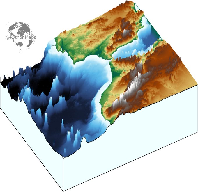
3D digital elevation model of the strait of Gibraltar for day 11 of the #30DayMapChallenge .
This map was made with #Python using #Numpy, #matplotlib and #earthpy. #data #DataScience #data #dataviz #DataScientist #eu #geography #artwork #art #Gibraltar #Brexit

Topography map of the greatest country in the world... Ireland. Colours correspond to the national flag obviously.
This map was made with #Python using #Numpy, #matplotlib and #Pandas. #data #DataScience #data #dataviz #DataScientist #Ireland #eu #geography #artwork #art

Contour line map showing the topography of Great Britain. Zoom in!
This map was made with #Python using #Numpy, #matplotlib and #earthpy. #data #DataScience #data #dataviz #DataScientist #uk #gb #eu #geography #artwork #art


Teamwork! Arrokoth and Numpy are a well oiled machine. Have a great weekend!
#teamwork #Arrokoth #Numpy #welloiledmachine #comicpanel #cartoon #illustration #aliens #scifi

Here are all of the rivers and waterways in Asia (excluding Russia), coloured according to the major hydrological basins they are part of. Zoom in! This map was generated using #Matplotlib #Numpy #Geopandas.
#Python #DataScience #Data #DataVisualization #Asia #China #India.