topographのTwitterイラスト検索結果。 699 件中 26ページ目


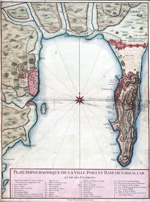
Topographic map of Gibraltar and the Bay of Gibraltar, circa 1750.


Topography map of France. Colours correspond to the of the national flag. #TopographyTuesday
This map was made with #Python using #Numpy, #matplotlib and #Pandas. #data #DataScience #data #dataviz #DataScientist #eu #geography #artwork #art #France #Map


Why have I been hard at work on the topography? For a commission, of course! This is what I've got going on now. Fist island! Probably monks live here or something. Heavily using QGis for this one! #cartography

Topography map of Kenya. Colours correspond to the of the national flag. #TopographyThursday
This map was made with #Python using #Numpy, #matplotlib and #Pandas. #data #DataScience #data #dataviz #DataScientist #eu #geography #artwork #art #Kenya #Africa #Map


#2021聴き逃し
音楽サイトやTLのベストから、アンビエントではこの4枚が素晴らしい聴き逃しやった
Brin, Dntel, More Eaze
Tapes and Topographies
Michal Turtle, Suso Saiz
Simon McCorry
マイベストにも入れたClaire RousayとのコラボアルバムがグレートなMore Eaze参加の作品がかなりいい


A little bit of map fun today with elevation data - a kind of topographic map, with lower elevations filling up first - spot the Danube, the Alps and all sorts of other things (elevation data from @CopernicusEU)


The unified IFSAR topography dataset of Alaska is ~0.44TB.
Here it is at 0.00818% in #rayshader with the imhof1 palette and snow_hs transformation applied. img is 635kb.
It had tile artifacts that were cleaned with the "<=0 = https://t.co/pP2DFHkMgL" transformation.


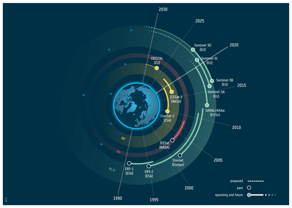

#Copernicus #Sentinels 🇪🇺🛰️
Discover #CRISTAL (Copernicus Polar Ice and Snow Topography Altimeter), one of six future expansion missions
Dedicated to measuring #SeaIce thickness, overlying snow depth, changes in the height of ice sheets & #glaciers
▶️ https://t.co/5q9MyddZqR

The result of mixing Dr. Seuss with topographic maps.
#genartclub #nft #fndinvite #art


Just wanted to show off my topographic style👀 #topography #30DayMapChallenge #artwork #digitalart

Forget Fate, 60 in x 68 in, oil on canvas, 2021. #samanthakeelysmith
#contemporarypaintings
#psychologicallandscapes
#landscapepaintingnow #abstractedtopographies
#abstractedlandscapes
#inventedworlds #innerworlds
#orderandchaos #oilpaint


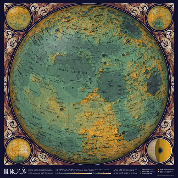

🎨🧬J'ai récemment découvert les illustrations scientifiques d'#EleanorLutz : cartes topographiques de la lune ou de mars, schémas biologiques en mouvement, carte des orbites du système solaire... Je suis éblouie. 🤩
➡️https://t.co/0pvv1Xbj4W
@womenwhodostuff #SciArt


@_Spaghetti4U THE PARALLELS.. THE CINNAMON TOPOGRAPHY........


Just dropped all 10 pieces from my 2014 series NEW TOPOGRAPHIES on @hicetnunc2000.
TYPOGRAPHY 001 through 010
x/10 ed (each) - 3 tez
🖼 https://t.co/znN7hf1ZhZ (001)
🔗 https://t.co/iHUVd6OXdK
#nftart #cleannft #nftcollector #nftcollectibles #nftartist #tezos #hicetnunc


New one:
Rhythm Rising Up, 60 in x 68 in, oil on canvas, 2021.
#samanthakeelysmith
#contemporarypaintings
#psychologicallandscapes
#landscapepaintingnow #abstractedtopographies
#abstractedlandscapes
#inventedworlds #innerworlds
#orderandchaos #oilpaint


#inktober #Inktober2021 #WitchWeekdays #compas #day16
Dedicated to all topographic cretins like me...🧭

Topography map of the greatest country in the world... Ireland. Colours correspond to the national flag obviously.
This map was made with #Python using #Numpy, #matplotlib and #Pandas. #data #DataScience #data #dataviz #DataScientist #Ireland #eu #geography #artwork #art