CAwxのTwitterイラスト検索結果。 27 件


Wet and cold weather is expected to continue into April, latest model guidance and forecasts suggest. Increased moisture influence in the coming weeks and more Alaskan lows! Breeding ground for more deepening pressure systems and severe weather in the Central US. #CAwx #WxTwitter https://t.co/VkQHwYuQH4


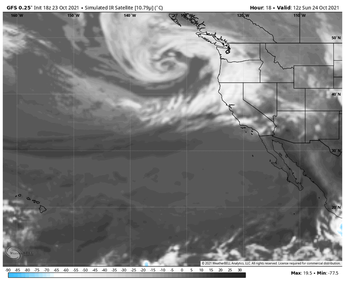
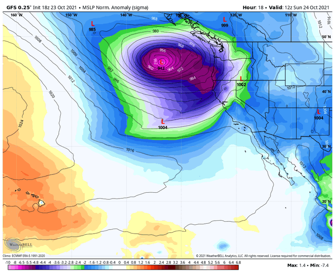
Alright California you know the drill, a potentially dangerous system is on its way and is forecasted to slam California on Tuesday. This system is a monster and isn’t playing around. It’s possible this will be worse than the bomb cyclone last week in some areas. #CAwx #WxTwitter

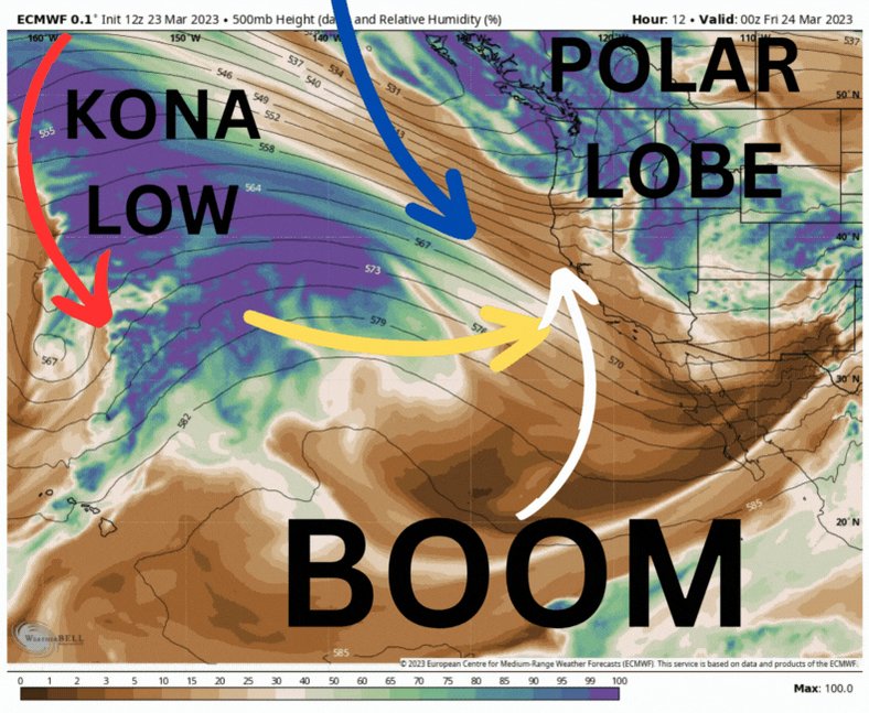
When a KONA low and a POLAR lobe get married they create a Bomb-Cyclone. Be sure not to miss the wedding next week just off the California Coastline #cawx


You better be kidding me about this one. The new ECMWF weeklies are out and they show above-normal precipitation totals possibly into early April. This would mean March could have very few rain-free days.
#CAwx #AtmosphericRiver #wxtwitter #PineappleExpress2023


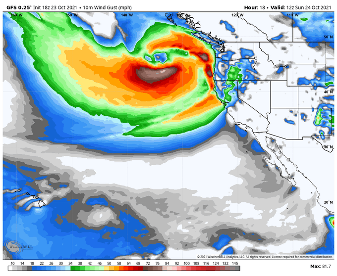
@GarciaCroft @debbedobee @JLHerms @BrettDNoble A very long-lived parade of strong Pacific storms. #California/Sierras ground 0! Colossal snowfalls. Many feet of #snow. Explosive, intense snowfall rates. #Sierra Front(#Reno/Carson City/#VirginiaCity) could get another heavy snow hit. #AtmosphericRiver #CAwx #NVwx #COwx #Rain


@studentoflife Your niece will be dealing with a series of storms over the next two weeks. There will be breaks in-between storm systems, a bit of good news. Pacific storm slated for Late Sunday-Tuesday looks like another doozy. Great news for the drought but not all at once. Yikes!😵#CAwx

22,400,000,000,000 gallons of water is a fairly conservative approximation of what will fall over the state of California over the next 15 days. That's 22 Trillion , 400 billion gallons! #cawx Too bad it cant all be caught and stored.


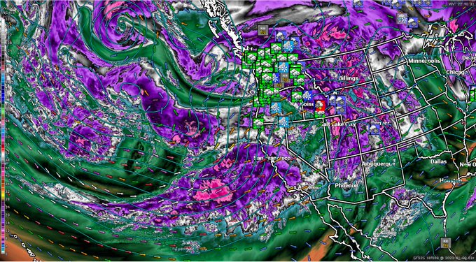
One of those storms where I could watch water vapor imagery on loop for hours. #CAwx #BombCyclone #AtmosphericRiver
Brace yourself, California!


It will remain stormy in CA for at least the next 7-10 days. The bigger storms will be Wed north spreading to the south Thur. A little more northern track to the Atmospheric River after Thur. But northern CA will see little break. My specific forecasts/impacts below. #cawx
The 12z EURO just had it's most bullish run YET w/ regards to precip in the West.
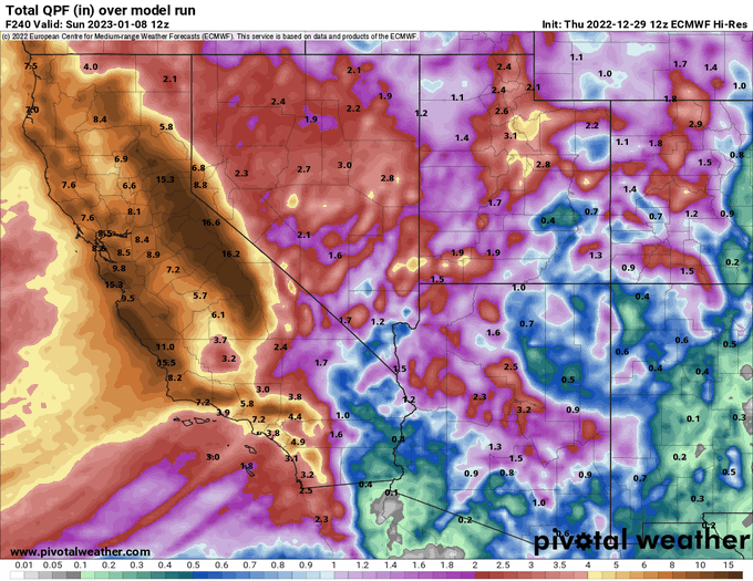
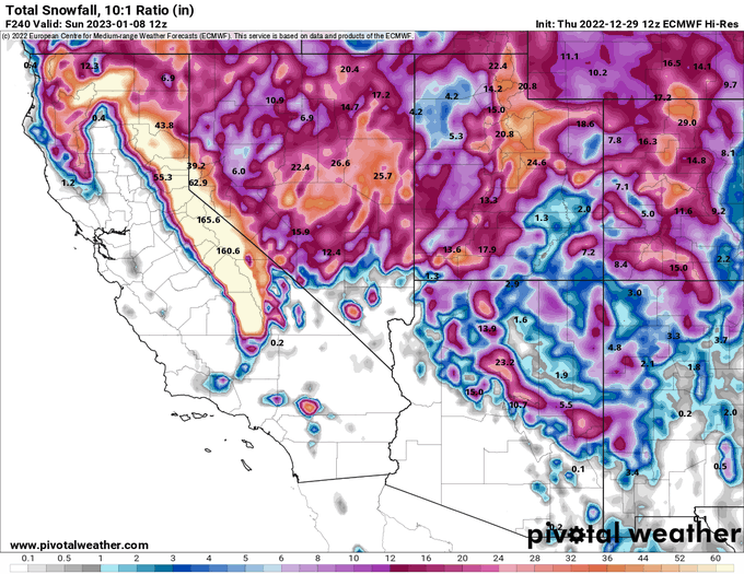
Over the next 10 days, it has vast expanses of California receiving 8"+ of rain, and well over 150" of snow in the Sierra Nevada.
Just a phenomenal sight to see #cawx #wxtwitter


4 medium range models have generally the same idea…more due midweek, off/on into Friday and possibly highest totals/wind later next weekend to early next week. 🌧 🪣 #CAwx


Model ensembles trending even wetter for NorCal between now & end of Oct. I'm personally skeptical that *this* much will actually fall, but I'm increasingly convinced of significant rain/mountain snow that will likely be fire-season ending from about I-80 northward. #CAwx #CAfire https://t.co/QFGsJxT9fs


#SATELLITE SPOTLIGHT: The #DixieFire northeast of Chico, California, continues to grow this week and @NOAA's #GOES17🛰️ captured its smoke and heat signature last evening. At last report, the #wildfire covered more than 60,000 acres and was only 15% contained. #CAwx

More monsoon soon? Mid-upper level moisture view shows upper level feature moving through that may trigger shower/isolated thunder into early Monday. Pattern looks favorable for another westward drift of mid-level moisture and shower chances later next wknd as well. #CAwx


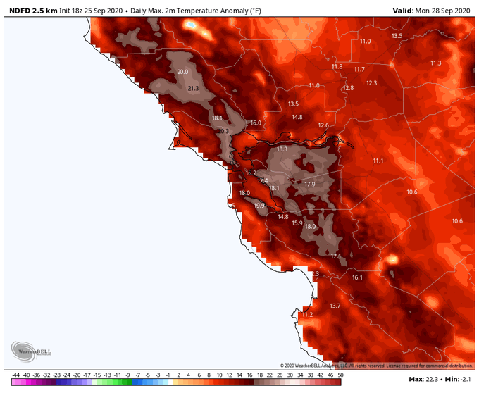
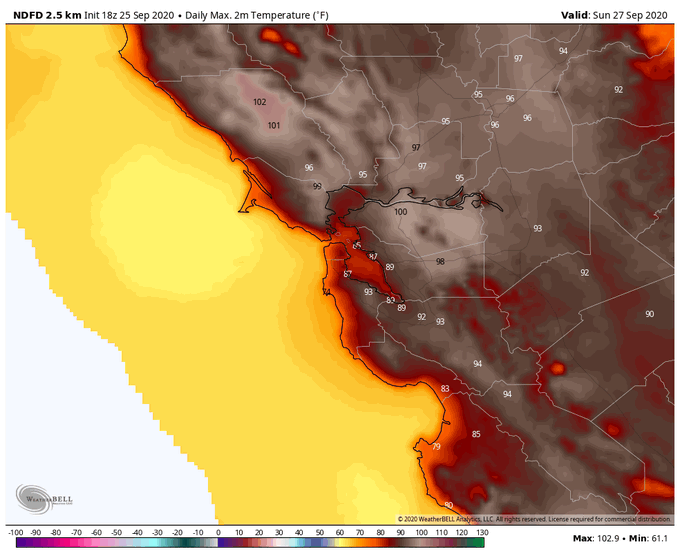
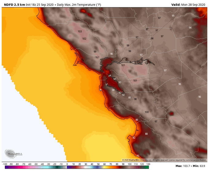
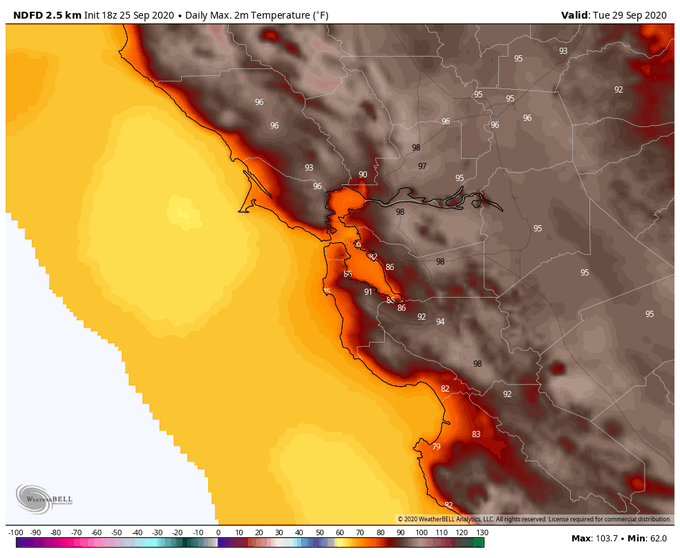
Models once again hinting at potential for major heatwave about a week from now. Operational runs hinting at what could be rather intense event, with June monthly temperatures records threatened, although ensembles more muted. Still, very strong heat signal for mid-June... #CAwx