gisのTwitterイラスト検索結果。 190 件中 6ページ目


@Stupacabra (actual answer if you fancy one, picked from random gis results)
* good
* look at them go!
* suits the subject
* doesn't look like the artist killed themselves against a punishing monthly schedule
* daft fun
* I feel like chucking it under the bed and reading another


dejo unos dibujos navideños que hice el año pasado para no quedarme atras jeje espero que les guste, algunos dibujos fueron practica de gis pastel Felices fiestas!! 💖🎄
#christmas #fanart #christmasart #FC #fantasy


art @Aegis57713873 emang yang terbaik
Aku padamu gis, lop yu
tapi aku bukan gay


For my final GIS project I mapped out how the nightly @MTA subway shutdowns disproportionally affect POC and essential workers across NYC.
My maps compare the coverage of the subway vs the replacement buses, overlaid with racial and occupational data.

Day 12 of #30DayMapChallenge - Map not made with GIS software
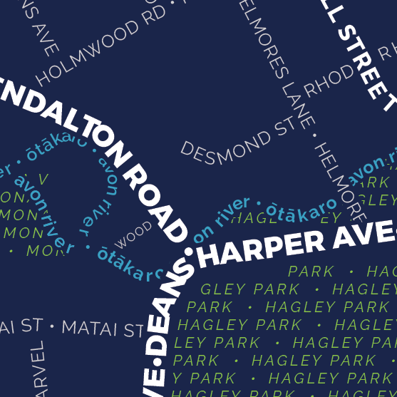
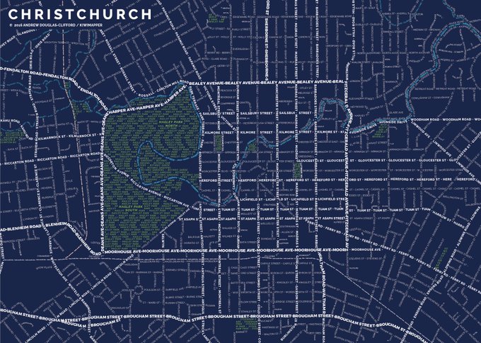
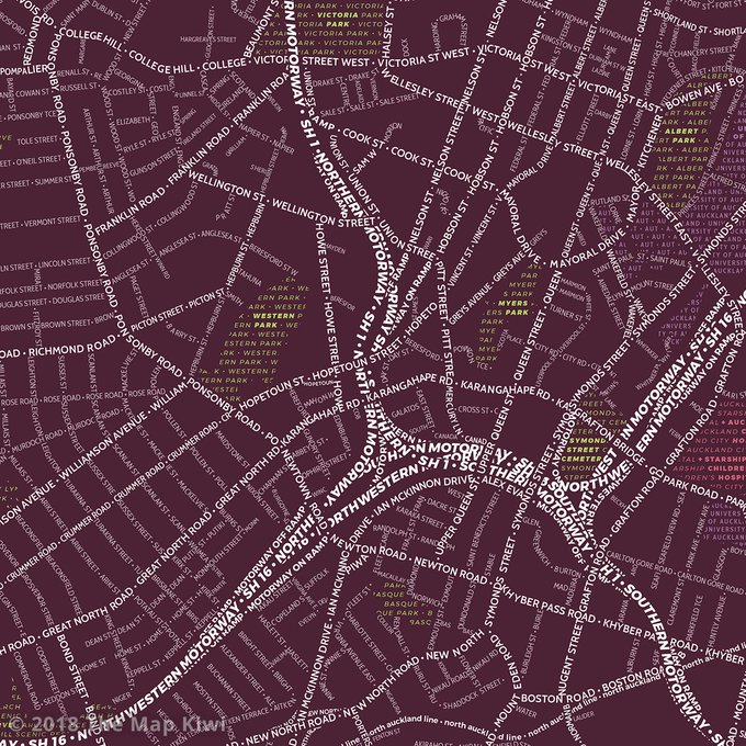
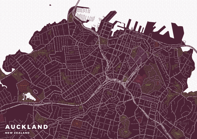
Auckland and Christchurch Typography maps (from the archives) - made with #OSM data and Illustrator.


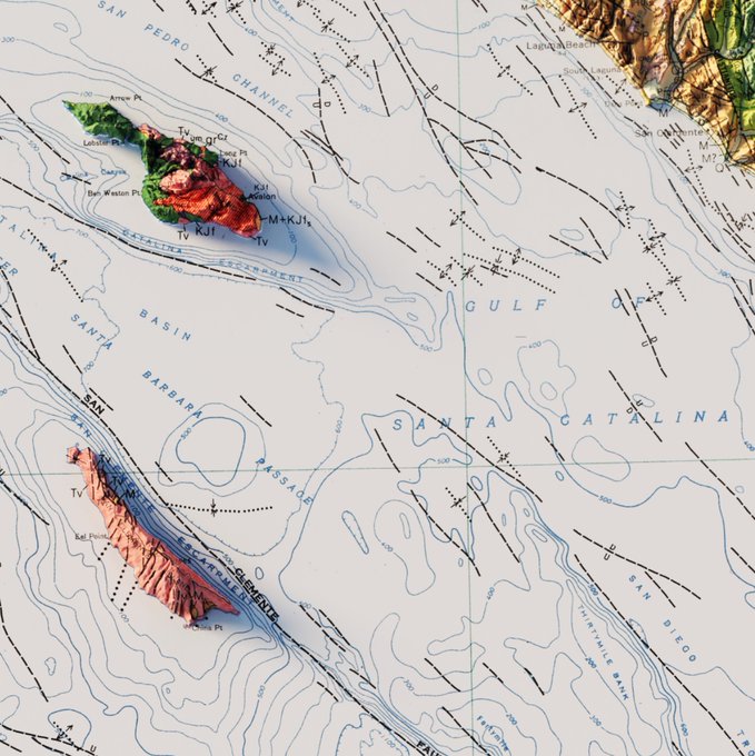

Geologic Map of California - 1977
#arcgispro #b3d #California #geology #geography #gis #dataviz


For #GeospatialSundays I want to share the R package {cartography} for creating ~beautiful~ thematic maps. I love the way these maps turn out and actually prefer them to ggplot2, sf, tmap, and mapview outputs. Check it out here: https://t.co/gmWjIhrkYh #rspatial #gis #cartography


Hiya, I'm Phil! bi & proud + environmental scientist & GIS specialist + an artist who loves drawing queer stuff & grumpy men ⚓️🏳️🌈
Patreon: https://t.co/7XFzNnMsaR
Redbubble: https://t.co/9uTtnNvOxV
Storenvy: https://t.co/QS4JpkTKjz
Ko-Fi: https://t.co/JkJC6OlCfo


There's a hastag called #STEMartists MY TIME HAS COME.
Hi I'm Eli and I'm a GIS Tech for an engineering firm!! I have a Bachelors in Wildlife Management/Biology and a Masters in Applied Science!!
I'm a hobby artist just trying to make my webcomic dream come true~

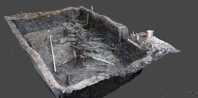
#DAIEurasien25: Vertical and horizontal logs, collapsed like a Mikado game, were unearthed during excavations in the #Gorbunovo peat bog. Photogrammetry, GIS, & dendrochronology helped assigning these wooden constructions to the late 3rd mill. BC.
https://t.co/5VtmMKt9TN


Tigre dorado de java
Tecnica mixta Colores Faber Castell con gis pastel <3


A JP MUGEN Wiki & other places have a page looking at two of the game's characters- Arabian Moon and Broadway / Cattydox, but no source.
https://t.co/LYOPRYZ8s8
This partial art also appears in GIS, but links nowhere, coloured versions of that art. From a game magazine, perhaps?


next up is my mans stahl and i'm so fond of this cipher it's so badass!!!!!
shout ot to his official art and gis confession to robin art they are also Very Good https://t.co/IPcBw0l2Zj

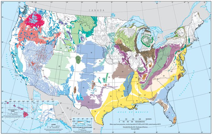
#MapOfTheWeek in honor of #ProtectYourGroundwaterDay (#PYGWD): @USGS PRINCIPAL AQUIFERS OF THE UNITED STATES
https://t.co/hsznsc7PcU 🗺️
https://t.co/NbVvc3oFub 🌊
#SciComm #EnvironmentalTwitter #NatureTwitter #EcoTwitter #GroundWater #Water #PublicHealth #GIS #PublicHealthMaps


Just found an old HDD at the bottom of a box in the garage. Didn't know where it came from.
Turns out it has my entire BSc dissertation on it, including all the raw GIS data and ArcGIS files from 8 years ago!
Glad to see I chose to store everything in "New File Geodatabase.gdb"


The map is not the terrain or 3 views of the same place, my fave mountain #mountsthelens #washington #gis #webgl #shadergraph


GeoIGN 2.3: グローバルな地質学のためのオープンGISデータリンク集 https://t.co/zUCRibuWnC
のために打ち出した地図たち

@walkingthedogg HELP HELP HELP HELP OH MY GIS OH YN GODDKDDDDD HELP

