GeospatialのTwitterイラスト検索結果。 11 件


🗺️A Map Showing Terrain Model of Mt.Rainier 🏔️( Pierce County, Washington, U.S🇺🇸) Data source from @OpenTopography (USGS10m) #MtRainier #gischat #cartography #dataviz #QGIS #Blender3d #DataVisualization #Geospatial


#keplergl is a great tool when you want to quickly graph a geographic dataset without any code! 🔥
Just upload your CSV, Json or GeoJSON!
👉 https://t.co/pepFoSlgna
#geospatial #DataScience #dataviz

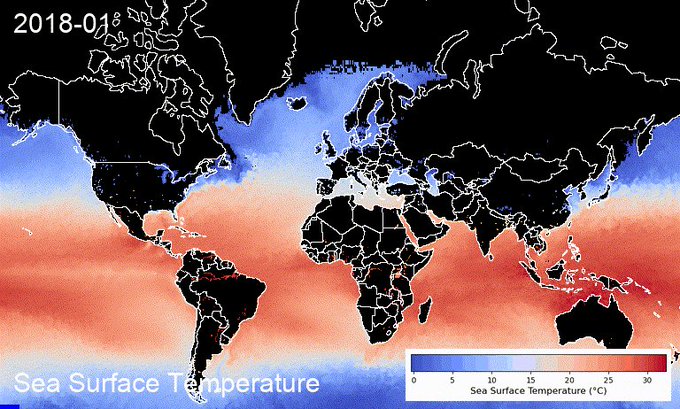
Happy New Year🎆 You can now create sea surface temperature timelapse with a colorbar using the #streamlit web app in <60 seconds 👇
App: https://t.co/LpcKK9yI6p
GitHub: https://t.co/ufznWiTnvs
#EarthEngine #geemap #eochat #gischat #oceancolor #dataviz #geospatial


Interested in a geospatial career after graduation?
Join Esri UK on Wednesday 18th November from 3-4pm for a virtual careers event. Get the inside track from current and former graduates on applying for their 2021 grad program
Sign up here 👉🏾 https://t.co/C7thAOaRjA #GISday


For #GeospatialSundays I want to share the R package {cartography} for creating ~beautiful~ thematic maps. I love the way these maps turn out and actually prefer them to ggplot2, sf, tmap, and mapview outputs. Check it out here: https://t.co/gmWjIhrkYh #rspatial #gis #cartography


Happy 22nd birthday to GDAL ! From the first commit on 1998-10-17 from a small rural town outside of Ottawa Canada, to almost every geospatial software installation on the planet (and satellites and other planets!) in 22 years. The ultimate example of sharing & community. #foss4g


R. Ufficio Geologico - Carta geologica delle Alpi occidentali - Dedotta Dai Rilevamenti Eseguiti Gagli Ingegneri del R. Corpo Delle Miniere, dal 188 al 1906 - Roma, 1908
#arcgispro #blender #maps #gis #dataviz #geological #cartography #copernicus #geospatial #3dart #3dmodeling

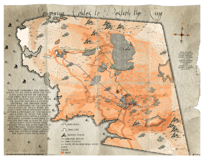
How #GeospatialAnalysis and #GIS could've helped the #FellowshipOfTheRing to find a better way (least cost analyses, anyone?) to Mount Doom 🌋 ...
https://t.co/fMF799Rmm4


#Geospatial Platform w/ #ReinforcementLearning Featuring @gp_pulipaka by @USATODAY. #BigData #Analytics #DataScience #AI #MachineLearning #AI #IoT #IIoT #Python #RStats #JavaScript #ReactJS #GoLang #CloudComputing #Serverless #DataScientist #Linux
https://t.co/z9MGSxevEE


Happy women’s day to the all the wonderful women in the world! Keep the awesomeness going 😇😎
#InternationalWomensDay #WomensDay2019 #WomenInGeospatial


Uberの位置情報ビジュアリゼーションのライブラリ。
位置情報データの動的な可視化は今年とてもやりたい事のひとつ。
From Beautiful Maps to Actionable Insights: Introducing https://t.co/ddKPBFmIGj, Uber's Open Source Geospatial Toolbox
https://t.co/YvPMBs7esX